
CON-250 · Lesson 5 of 12 · 29 min
Coordinates, stationing and horizontal curves
Modern layout is done almost entirely with coordinates. The designer's model assigns a northing, easting and elevation to every building corner, gridline intersection, curb point and manhole, and the total station or GNSS rover guides the crew to each one. Behind the screen of the data collector, the calculations are a handful of simple coordinate geometry operations. A construction manager who understands them can check a layout, compute a missing point, spot an impossible dimension and talk confidently with surveyors and designers. This lesson covers the coordinate geometry used in layout, the stationing system used for linear works, and the geometry of horizontal circular curves.
The inverse: distance and direction from coordinates
The most common calculation in surveying is the inverse: given the coordinates of two points, find the horizontal distance and the azimuth between them. It is used to check that two control points are where they should be, to find the distance between building corners and to compute the angle a total station must turn.
The arctangent gives an angle between −90° and +90°, so the quadrant must be found from the signs of ΔN and ΔE. If ΔN is positive and ΔE positive, the azimuth is in the northeast quadrant and equals the arctangent. If ΔN is negative, add 180°. If ΔN is positive and ΔE negative, add 360°. Calculators and spreadsheets with an ATAN2 function handle this automatically, but it is worth sketching the points to make sure the answer points the right way.
Worked problem
Inverse between two points
Control point A is at N 1000.000, E 1000.000. A building corner P is at N 1043.250, E 1087.640. Find the distance and azimuth from A to P.
Show solution
- ΔN = +43.250; ΔE = +87.640. Both positive, so the line points northeast.
- D = √(43.250² + 87.640²) = √(1,870.56 + 7,680.77) = √9,551.33 = 97.731 m.
- Az = arctan(87.640 ÷ 43.250) = arctan(2.0264) = 63°44′02″.
Answer: 97.731 m at an azimuth of 63°44′02″.
The forward computation: coordinates from direction and distance
The reverse operation, sometimes called a polar or radiation computation, finds the coordinates of a new point from a known point, an azimuth and a distance. It is how a total station computes the position of every point it measures, and how a designer calculates offset points.
Computing layout data from a setup
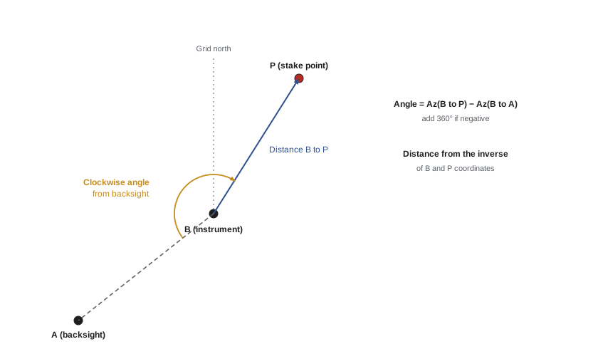
To stake a point with a total station set up over a control point, the instrument needs the angle to turn from the backsight and the distance to the point. Both come from inverses. The software does this automatically, but if you can do it by hand you can check any stakeout and you will understand what goes wrong when the wrong backsight is entered.
- Inverse from the instrument station to the backsight to get the backsight azimuth.
- Inverse from the instrument station to the point to be staked to get its azimuth and distance.
- The clockwise angle to turn equals the azimuth to the point minus the backsight azimuth, plus 360° if the result is negative.
Worked problem
Layout data for a stake point
A total station is at B (N 1111.765, E 1088.124) with a backsight on A; the azimuth from B to A is 218°15′27″. Stake point P is at N 1073.978, E 1107.794. Find the angle to turn and the distance.
Show solution
- ΔN = 1073.978 − 1111.765 = −37.787; ΔE = 1107.794 − 1088.124 = +19.670.
- D = √(37.787² + 19.670²) = 42.600 m.
- ΔN negative, so Az = arctan(19.670 ÷ −37.787) + 180° = −27°30′00″ + 180° = 152°30′00″.
- Angle to turn = 152°30′00″ − 218°15′27″ + 360° = 294°14′33″ clockwise from A.
Answer: Turn 294°14′33″ clockwise from A and measure 42.600 m.
The same arithmetic explains why a wrong backsight is so serious. If the instrument is oriented on the wrong point, every azimuth is rotated by the same angle, and every staked point is swung around the instrument. Points close to the instrument move a little and points far away move a lot. A check shot to a third control point catches this immediately.
Intersections and offsets
Two other coordinate operations come up regularly. An intersection finds the point where two lines cross, for example where a new curb line meets an existing property line, or where two gridlines meet. It can be computed from the coordinates and azimuths of both lines; CAD and survey software do it in a keystroke. An offset finds the perpendicular distance from a point to a line, which is how a surveyor reports that a new wall is 12 millimetres off its gridline, or that a fence is 0.35 metres inside a property line.
For a line from point A at azimuth Az, the perpendicular offset of point P equals the distance from A to P multiplied by the sine of the angle between the line and the direction A to P. The distance along the line equals the same distance multiplied by the cosine. These two values, along and offset, are the basis of stationing.
Stationing and offsets
Roads, pipes, curbs, retaining walls and other linear works are located by station and offset rather than by coordinates. The station is the distance measured along a reference line, the alignment or centreline, from its starting point. The offset is the perpendicular distance left or right of the alignment, looking in the direction of increasing stations.
In Canada stations are written in kilometres and metres: station 1+245.600 is 1,245.600 metres from the start. An offset of 7.500 m right means 7.5 metres to the right of the centreline looking up-station. Cross-sections and grade stakes are usually set at regular intervals, such as every 20 metres on a road, with extra stations at changes in geometry and at structures.
Stationing has some quirks. Alignments are sometimes revised after construction starts, leaving a station equation, a point where two different station values apply, such as back station 2+050.000 equals ahead station 2+047.350. Stationing on a curve follows the arc length along the centreline, not the chord. And offsets on the inside of a curve are shorter in arc length than the centreline, while those on the outside are longer, which matters when computing quantities for curbs and barriers.
Horizontal circular curves
Where a road, curb, railway or pipeline changes direction, the two straight sections, called tangents, are joined by a curve. The simplest is a circular arc of constant radius. Highways also use spiral (transition) curves, whose radius changes gradually so that drivers can steer smoothly, but most site roads, parking lots and curbs use simple circular curves.
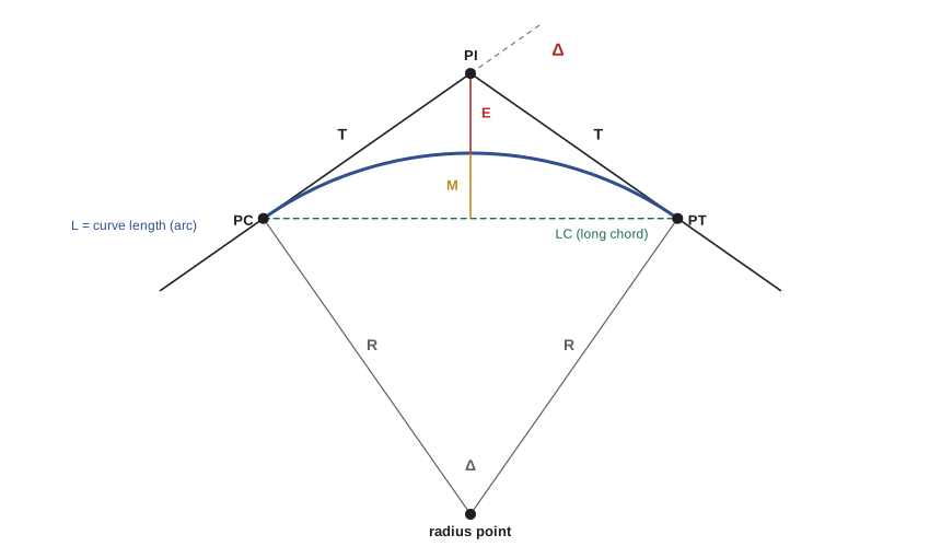
The curve is defined by the point where the tangents meet, the point of intersection (PI), the deflection angle Δ between the tangents, and the radius R. Everything else follows.
| Element | Symbol | Formula |
|---|---|---|
| Tangent length (PI to PC or PT) | T | R tan(Δ/2) |
| Length of curve (arc) | L | π R Δ ÷ 180 (Δ in degrees) |
| Long chord (PC to PT) | LC | 2R sin(Δ/2) |
| External distance (PI to curve midpoint) | E | R (1 ÷ cos(Δ/2) − 1) |
| Middle ordinate (chord midpoint to curve) | M | R (1 − cos(Δ/2)) |
| Station of PC | PC | PI station − T |
| Station of PT | PT | PC station + L |
Note that the station of the PT is the station of the PC plus the curve length, not the PI station plus the tangent. Stationing follows the curve, which is shorter than the two tangents. Forgetting this is one of the most common errors in curve calculations.
Canadian design uses the radius directly. US highway practice has traditionally also described curves by their degree of curvature, the central angle subtended by a 100-foot arc, but metric design uses radius only.
Worked problem
Computing a curve
Two tangents of a site road meet at PI station 1+245.600 with a deflection angle of 36°20′. The design radius is 300.000 m. Find T, L, LC, E, M and the stations of the PC and PT.
Show solution
- Δ = 36.3333°; Δ/2 = 18.1667°.
- T = 300 × tan 18.1667° = 98.442 m. L = π × 300 × 36.3333 ÷ 180 = 190.241 m.
- LC = 2 × 300 × sin 18.1667° = 187.069 m. E = 300 × (1 ÷ cos 18.1667° − 1) = 15.738 m. M = 300 × (1 − cos 18.1667°) = 14.954 m.
- PC = 1+245.600 − 98.442 = 1+147.158. PT = 1+147.158 + 190.241 = 1+337.399.
Answer: PC at 1+147.158 and PT at 1+337.399; the curve is 190.241 m long.
Laying out a curve
Curves can be laid out in two ways. The traditional method is by deflection angles: the instrument is set up on the PC, sighted along the back tangent towards the PI, and each point on the curve is located by turning a deflection angle and measuring a chord from the previous point. The deflection angle to any point on the curve is half the central angle subtended by the arc to that point.
Here ℓ is the arc length from the PC to the point and c is the chord length. With modern instruments, curves are more often laid out by coordinates: the design software computes the northing and easting of each station and offset point on the curve, and the total station or rover simply navigates to them. The deflection method remains useful for checking, and for understanding what the software is doing.
Worked problem
Deflection to the first station on the curve
For the curve above (R = 300.000 m, PC at 1+147.158), stakes are set at every 20 m station. Find the deflection angle and chord from the PC to station 1+160.
Show solution
- Arc length ℓ = 1,160.000 − 1,147.158 = 12.842 m.
- δ = 90 × 12.842 ÷ (π × 300) = 1.2263° = 1°13′35″.
- Chord c = 2 × 300 × sin 1.2263° = 12.841 m.
- Each further 20 m arc adds 90 × 20 ÷ (π × 300) = 1°54′35″ of deflection.
Answer: Turn 1°13′35″ from the back tangent and measure a 12.841 m chord.
A useful check: the total deflection from the PC to the PT must equal Δ/2. In the example it is 18°10′, half of 36°20′. If the accumulated deflections do not reach Δ/2 at the PT, there is an error in the stations or the arithmetic.
Curves in buildings and site work
Building projects use curves too: curved walls and facades, radius curbs at parking lot corners, curved ramps and circular tanks. For a curved wall, the layout surveyor will usually stake the radius point (if accessible) and a series of points on the wall at regular arc intervals, or compute coordinates directly. For radius curbs, the field method of stretching a tape from the radius point is still common, provided the radius point is set accurately. Remember the middle ordinate when checking curved formwork: a chord stretched between two points on the form should be the computed middle ordinate away from the form at its midpoint.
Checking designs and layouts
Coordinate geometry gives a construction manager powerful checks on design and layout information before anything is built.
- Inverse between the coordinates of gridline intersections and compare the results with the dimensions on the drawings. A mismatch reveals a drafting error or a misplaced point.
- Check that curve data closes: T, L and Δ should be consistent with R, and the PT station should equal the PC station plus L.
- Compute the area of the building footprint from its corner coordinates and compare it with the area on the drawings.
- Compare staked points with as-built measurements and record the differences in the layout log.
These checks take minutes and routinely catch errors that would otherwise cost days.
Common mistakes
MistakeUsing the arctangent result without checking the quadrant.
InsteadUse ATAN2 or check the signs of ΔN and ΔE; sketch the points to confirm the direction.
MistakeComputing the PT station as PI station + T.
InsteadStationing follows the curve: PT = PC + L.
MistakeConfusing the deflection angle with the central angle.
InsteadThe deflection angle from the tangent to a point is half the central angle to that point.
MistakeOrienting on the wrong backsight.
InsteadA wrong backsight rotates every staked point; always take a check shot.
MistakeIgnoring station equations after a design revision.
InsteadNote station equations on the plans and in the data collector so stations are not misapplied.
MistakeTrusting coordinates in a design file without checking them against dimensions.
InsteadInverse between key points and compare with the drawing dimensions before staking.
Summary and key terms
- An inverse gives distance and azimuth from two sets of coordinates; check the quadrant from the signs of ΔN and ΔE.
- Forward computation gives new coordinates from a known point, an azimuth and a distance.
- Layout angle = azimuth to the point − backsight azimuth (plus 360° if negative).
- Linear works are located by station along an alignment and offset left or right.
- A simple curve is defined by its PI, deflection angle Δ and radius R; T = R tan(Δ/2) and L = πRΔ/180.
- PC = PI − T, and PT = PC + L, not PI + T.
- Deflection angles from the PC equal half the central angle, and total Δ/2 at the PT.
- Inverse
- The computation of distance and azimuth between two coordinated points.
- Forward computation
- Computing new coordinates from a known point, azimuth and distance.
- Station
- Distance measured along an alignment from its start.
- Offset
- Perpendicular distance left or right of an alignment.
- Station equation
- A point where two different station values apply after a revision.
- PI
- Point of intersection of two tangents.
- PC and PT
- The beginning and end of a horizontal curve.
- Deflection angle (Δ)
- The change in direction between two tangents.
- Tangent length
- The distance from the PI to the PC or PT.
- Middle ordinate
- The distance from the midpoint of the long chord to the curve.
Practice problems
Work each problem on paper first, then reveal the answer to check.
Find the distance and azimuth from N 500.000, E 500.000 to N 460.000, E 530.000.
Show answer
ΔN = −40, ΔE = +30; D = 50.000 m; Az = 180° − 36°52′12″ = 143°07′48″.
From N 200.000, E 300.000, go 25.000 m at an azimuth of 90°. Where are you?
Show answer
N 200.000, E 325.000.
The backsight azimuth is 300°00′ and the azimuth to the stake point is 45°00′. What clockwise angle is turned?
Show answer
45° − 300° + 360° = 105°00′.
A curve has R = 150 m and Δ = 60°. Find T and L.
Show answer
T = 150 × tan 30° = 86.603 m; L = π × 150 × 60 ÷ 180 = 157.080 m.
For that curve, the PI is at 0+500.000. Find the PC and PT stations.
Show answer
PC = 0+413.397; PT = 0+570.477.
What should the total deflection angle from the PC to the PT equal?
Show answer
Half the curve's deflection angle, Δ/2.
Why is a check shot important after orienting on a backsight?
Show answer
A wrong backsight rotates every point staked from that setup; the check shot catches it before any points are set.
Name two checks a construction manager can do on design coordinates.
Show answer
Inverse between gridline intersections and compare with dimensions; check that curve data is consistent; compare footprint area.
Lesson quiz · 5 questions
Score 60% or more to complete this lesson.
Create a free account to save your progress, take quizzes and earn a certificate.