
PHOT-350 · Lesson 10 of 12 · 29 min
Privacy, ethics and community relations
Drones make many people uneasy. A buzzing aircraft over a backyard, a camera hovering near a window or a drone circling a beach can feel like surveillance, even when the pilot is photographing something else entirely. Public complaints shape regulation, and one careless flight can lead to a confrontation, a police call, a lawsuit or a viral video that harms a business. Aviation rules (lesson 3) say where and how a drone may fly; privacy, trespass and wildlife laws, and ordinary decency, say what a drone operator should and should not record. This lesson covers how privacy law applies to aerial imaging in Canada and the United States, airspace and trespass, wildlife disturbance, Indigenous lands and sacred places, noise and community relations, and practical habits that keep aerial photographers welcome.
Why aerial privacy is different
Ground photographers generally work in public places where people have a reduced expectation of privacy (see the street photography lessons in earlier courses). Drones change the picture because they can see over fences, hedges and walls, into backyards, pools, balconies and windows that are hidden from the street. They can hover, follow people, zoom and record continuously, and they are often hard to trace back to their pilot. Courts and regulators have recognized that the elevated, persistent view a drone provides can intrude where a ground camera could not, so the same photograph that would be lawful from the sidewalk may be unlawful or actionable from above someone's yard.
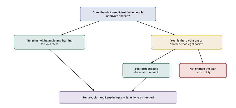
The ethical test is useful even where the law is unclear: would a reasonable person feel watched or exposed if they knew this image was being made, and is there a good reason to make it? Commercial work rarely needs identifiable images of uninvolved people, so most privacy problems can be avoided through planning: choosing angles and times, flying higher, framing out neighbors, blurring faces and license plates, and asking permission.
Privacy law
In the United States, there is no general federal privacy law covering private drone photography. The Fourth Amendment limits government surveillance, not private photographers. Instead, privacy protection comes from state law: common-law privacy torts such as intrusion upon seclusion and public disclosure of private facts, state right-of-publicity laws that restrict commercial use of a person's image or likeness, voyeurism and peeping laws, and, in many states, drone-specific statutes. Comprehensive state consumer privacy laws, such as the California Consumer Privacy Act as amended, can also apply to businesses that collect personal information, including images, above certain size thresholds. The National Telecommunications and Information Administration published voluntary best practices for privacy in commercial drone use in 2016, encouraging operators to avoid persistent surveillance, limit retention and give notice.
Several states have drone-specific laws. Texas restricts capturing images of people or private property with a drone for surveillance, with listed exceptions; the federal Fifth Circuit upheld key parts of the law against a press-freedom challenge in 2024, though litigation has continued. Florida limits using drones to capture images of privately owned property or people on it in violation of their reasonable expectation of privacy. California's constructive invasion of privacy law covers using any device to capture images of people in personal or family activity where they would otherwise need to trespass. Voyeurism statutes in every state can apply to drones. Because laws vary widely, operators should check the rules of each state they work in.
How identifiable is a person from the air?
Whether a person is identifiable depends on resolution as well as angle. From directly above at 60 meters, a person may be a few dozen pixels across the shoulders and the top of a head, hard to recognize. In an oblique view with a zoom lens, the same person's face can be clear. A practical guide used in video surveillance is that around 40 pixels across a face allows a familiar person to be recognized, and around 80 to 100 or more pixels allows identification of strangers.
Worked problem
Could a face be recognized?
A drone camera has 2.4 µm pixels. With the wide lens (4.5 mm), the drone is 30 m from a person. With a zoom at 70 mm, it is 80 m away. A face is about 0.16 m wide. How many pixels cover the face in each case?
Show solution
- Wide: GSD = 0.0000024 × 30 ÷ 0.0045 = 0.016 m; face ≈ 0.16 ÷ 0.016 = 10 pixels.
- Zoom: GSD = 0.0000024 × 80 ÷ 0.070 ≈ 0.0027 m; face ≈ 0.16 ÷ 0.0027 ≈ 58 pixels.
- Compare with about 40 pixels for recognizing a familiar person.
Answer: About 10 pixels with the wide lens, not recognizable; about 58 pixels with the zoom, enough to recognize someone. Zoom lenses raise privacy stakes even from farther away.
Airspace, trespass and nuisance
Who owns the air above land? Old common law said a landowner owned "up to the heavens", but aviation made that impossible. Courts now hold that landowners control the airspace they can reasonably use and enjoy, while navigable airspace belongs to everyone under the aviation regulator. Drones fly in the uncertain zone in between: low enough that a hovering drone over a backyard may be a trespass or a nuisance, high enough that aviation law also applies.
In the United States, the Supreme Court's decision in United States v. Causby (1946) held that landowners own at least as much of the airspace above them as they can occupy or use, and that frequent low flights can be a taking or trespass. The FAA regulates navigable airspace, while states and courts handle trespass and nuisance; the exact height at which drone flights stop being trespass is unsettled. Taking off or landing on private property without permission is a trespass, and shooting down or damaging a drone is a federal crime because drones are aircraft.
The practical rule is to get permission from landowners for take-off, landing and flights at low height over their property, to avoid hovering over neighboring properties, and to fly over roads, public land or the client's own property where possible.
Wildlife and the environment
Drones disturb wildlife. Birds may abandon nests, flush from colonies or attack drones; seals and sea lions may stampede into the water, crushing pups; deer, moose and bears may run. Disturbance can be illegal as well as unethical, especially in nesting season and around species at risk. Good practice is to keep a large distance, fly high, avoid hovering over animals, approach slowly and never chase or herd them. If animals show signs of stress, such as raising heads, calling, moving away or circling, the pilot should back off immediately.
In the United States, the Migratory Bird Treaty Act and the Bald and Golden Eagle Protection Act prohibit taking or disturbing protected birds, and the Endangered Species Act protects listed species and critical habitat. The Marine Mammal Protection Act prohibits harassment of marine mammals, and NOAA guidance recommends that drones stay at least about 100 yards from whales and dolphins, with larger distances for some species, such as the federal 500-yard approach limit for North Atlantic right whales, and that aircraft, including drones, avoid flying low over marine mammals. Drones are banned in national parks without authorization, and some wildlife refuges and state parks restrict them.
Worked problem
Keeping distance from whales
A photographer wants to film a humpback whale from a drone while staying at least 100 yd (about 91 m) away. A zoom camera with 2.4 µm pixels at 70 mm is used. About how many pixels will a 14 m whale span at 91 m?
Show solution
- GSD = 0.0000024 × 91 ÷ 0.070 ≈ 0.0031 m.
- Pixels = 14 ÷ 0.0031 ≈ 4,500.
- The whale nearly fills a 5,000-pixel-wide frame.
Answer: Thousands of pixels: a zoom lens lets the photographer respect the legal distance and still fill the frame, so there is no photographic reason to approach closer.
Indigenous lands, sacred places and cultural sites
Many places that look like open land are Indigenous territories, reserves or sites of cultural and spiritual importance. Flying over or photographing them without permission can cause real harm, from intruding on ceremonies to exposing the locations of sacred or archaeological sites to looting.
In the United States, federally recognized tribes are sovereign nations, and many regulate drone use on tribal lands; some require permits and fees for commercial filming. Before flying over or near tribal lands, operators should contact the tribe, ask about permission and protocols, and respect restrictions on photographing ceremonies, burial grounds and sacred sites. Federal laws such as the Archaeological Resources Protection Act protect archaeological sites on federal and tribal lands, and publishing precise locations can encourage looting.
Noise and community relations
Even a lawful flight can annoy people. Small camera drones produce a high-pitched whine that carries farther than many pilots expect. Sound level falls by about 6 decibels each time the distance doubles, so climbing higher is one of the easiest ways to reduce disturbance.
Worked problem
How loud is the drone at a neighbor's yard?
A drone produces about 75 dB at 2 m. How loud is it at 30 m and at 120 m, ignoring wind and background noise?
Show solution
- At 30 m: 75 − 20 log₁₀(15) = 75 − 23.5 ≈ 51.5 dB.
- At 120 m: 75 − 20 log₁₀(60) = 75 − 35.6 ≈ 39.4 dB.
- 51 dB is like a quiet conversation; 39 dB is like a quiet library.
Answer: About 52 dB at 30 m and 39 dB at 120 m. Flying higher makes the drone far less intrusive.
Good community relations are part of professionalism. Before a job in a residential area, many operators knock on neighbors' doors or leave a note explaining the flight, its purpose and timing. On site, a high-visibility vest, a sign stating the operator's name and contact details, and a calm, friendly attitude defuse most concerns. If someone objects, the pilot should listen, explain what is and is not being recorded, offer to show the footage and, where reasonable, change the plan. Arguments with members of the public rarely end well and are often filmed.
Handling images responsibly
Responsible handling continues after landing. Images of identifiable uninvolved people, vehicle license plates, house numbers and private yards should be cropped, blurred or not published unless there is consent or a clear public interest. Raw footage should be stored securely and deleted when no longer needed. Clients should be told what personal information the footage contains, and contracts should state who may use it and for what (lesson 11). Selling or posting footage of people in their homes or yards, even accidentally captured, can create legal liability and damage trust.
| Situation | Risk | Better practice |
|---|---|---|
| Real estate shoot next to a neighbor's pool | Intrusion on privacy | Frame out the pool, fly higher or ask permission |
| Event on a public beach | Identifiable people, flying over people | Stay within the rules on people; blur faces in delivery |
| Construction progress map | Workers identifiable, adjacent homes | Inform the site; crop neighboring properties |
| Wildlife colony at sunrise | Disturbance, legal violations | Keep legal distances, fly high, use zoom |
| Ceremony on Indigenous land | Cultural harm, trespass | Ask the community government first; respect refusals |
Common mistakes
MistakeAssuming a lawful flight path makes any image lawful.
InsteadRemember privacy, trespass and wildlife laws apply separately from aviation rules.
MistakeHovering over a neighbor's backyard for the perfect angle.
InsteadPlan angles that avoid private spaces, or ask permission.
MistakeApproaching wildlife closely for a dramatic shot.
InsteadKeep legal distances and use a zoom lens.
MistakeArguing with a member of the public who objects.
InsteadListen, explain, show footage and adjust the plan where reasonable.
MistakePublishing footage with identifiable bystanders and license plates.
InsteadCrop or blur them unless there is consent or a clear public interest.
Summary and key terms
- Drones can see into private spaces, so privacy risks are higher than for ground photography.
- State privacy torts, publicity rights, voyeurism laws and drone statutes govern aerial images.
- Identifiability depends on resolution; zoom lenses can make faces recognizable from far away.
- Low flights over private land can be trespass or nuisance, and damaging a drone is also illegal.
- Wildlife laws set approach distances and prohibit disturbing nests and marine mammals.
- Indigenous communities and cultural sites need permission and respect.
- Sound falls about 6 dB per doubling of distance; community relations and careful image handling keep operators welcome.
Practice problems
Work each problem on paper first, then reveal the answer to check.
Why can a drone photo be more intrusive than one taken from the sidewalk?
Show answer
It can see over fences and walls into spaces hidden from public view.
Name two ways to avoid capturing identifiable bystanders.
Show answer
Fly higher, change angle or timing, frame them out, or blur them later.
A face covers 30 pixels. Is it likely recognizable?
Show answer
Probably not by strangers; around 40 pixels is a rough threshold for recognizing a familiar person.
Is it legal for a homeowner to knock a drone down over their yard?
Show answer
No; damaging a drone can be a crime, though the pilot may face trespass or privacy claims.
What distance do Canadian rules generally set from whales?
Show answer
At least 100 meters, more for some species and areas.
A drone is 70 dB at 4 m. How loud is it at 64 m?
Show answer
70 − 20 log₁₀(16) ≈ 70 − 24 = 46 dB.
What should an operator do before flying near an Indigenous community?
Show answer
Contact the local government, ask permission and follow its protocols.
Why is posting a precise archaeological site location harmful?
Show answer
It can lead to looting and may break heritage law.
Give two community relations habits for residential jobs.
Show answer
Notify neighbors in advance and wear a vest with contact details on site.
What does data minimization mean for drone footage?
Show answer
Capture and keep only the personal information needed, and delete the rest.
Lesson quiz · 5 questions
Score 60% or more to complete this lesson.
Create a free account to save your progress, take quizzes and earn a certificate.