
PHOT-330 · Lesson 2 of 12 · 34 min
Planning for light, weather and seasons
Most memorable landscape photographs are planned. The photographer knew where the sun would rise, what the weather was likely to do, when the tide would be low, which week the larches would turn gold, and how long it would take to hike to the viewpoint in the dark. This lesson turns planning into a repeatable process: scouting, reading sun, moon and twilight data at different latitudes and seasons, using weather forecasts and satellite imagery, timing tides, forecasting the aurora, and building a plan with backup options. The basics of sun elevation, azimuth and twilight were covered in PHOT-311; here we apply them to wild places and longer time scales.
The planning loop
Planning works best as a loop rather than a single step. First, research: study maps, satellite views, guidebooks and other photographers' work to find promising places. Second, scout: visit in person, ideally at a different time from when you plan to shoot, to check access, compositions and hazards. Third, predict: use sun, moon, tide and weather tools to choose dates and times when the light and conditions are likely to be good. Fourth, shoot, with backups for when conditions change. Fifth, review: note what worked, what the light actually did and what you would change, and feed that back into the next plan. Over time, a photographer builds a personal database of places and conditions that no app can match.
Planning tools
Several kinds of tools help, and most photographers use a combination. Sun and moon apps and websites show the direction and elevation of the sun and moon for any place and time, often overlaid on a map, so you can see where the light will come from and whether a mountain will block it. Topographic maps and elevation models show terrain, slopes and lines of sight. Satellite and aerial imagery reveal clearings, shorelines and access roads. Tide tables give the times and heights of high and low water. Weather forecasts, radar and satellite cloud imagery help predict clearing storms, fog and colourful skies. Aurora forecasts give space weather indices. Field guides and phenology reports tell you when flowers bloom, birds migrate and leaves change.
Tools change frequently, so this course describes categories rather than recommending particular apps. Whatever you use, check that it uses the correct time zone and daylight saving setting, and that its elevation data includes the local horizon. A sunrise time calculated for a flat horizon can be 20 to 40 minutes too early in a mountain valley.
Latitude, season and the length of the light
Latitude has a huge effect on light. Near the equator, the sun rises and sets steeply, golden hour and twilight are short, and day length changes little through the year. At high latitudes, the sun moves at a shallow angle to the horizon, so golden light and twilight last much longer, and day length swings dramatically with the seasons. Much of Canada and Alaska lies far enough north that summer nights never get fully dark and winter days are short with a low sun.
The approximate day length at a given latitude and date can be calculated from the sun's declination, its angle north or south of the celestial equator, which ranges from about +23.4 degrees at the June solstice to about −23.4 degrees at the December solstice. The hour angle at sunrise, \( H_0 \), satisfies:
where \( \varphi \) is the latitude and \( \delta \) the declination. Day length in hours is about \( 2H_0/15 \) when \( H_0 \) is in degrees. This simple version ignores refraction and the size of the sun's disc, which add a few minutes.
Worked problem
Day length at the solstices
Estimate the day length at the June and December solstices for Toronto (latitude 43.7° N) and Whitehorse (60.7° N).
Show solution
- June, Toronto: \( \cos H_0 = -\tan 43.7° \tan 23.4° = -0.956 \times 0.433 = -0.414 \), so \( H_0 = 114.4° \) and day length is about 15.3 hours.
- December, Toronto: \( \cos H_0 = +0.414 \), \( H_0 = 65.6° \), about 8.7 hours.
- June, Whitehorse: \( \cos H_0 = -\tan 60.7° \times 0.433 = -1.782 \times 0.433 = -0.772 \), \( H_0 = 140.5° \), about 18.7 hours.
- December, Whitehorse: \( \cos H_0 = +0.772 \), \( H_0 = 39.5° \), about 5.3 hours.
Answer: Toronto ranges from about 15.3 to 8.7 hours; Whitehorse from about 18.7 to 5.3 hours (refraction adds a little to each). In the North, summer shoots stretch late into the night, while winter offers short days with low, warm light at midday.
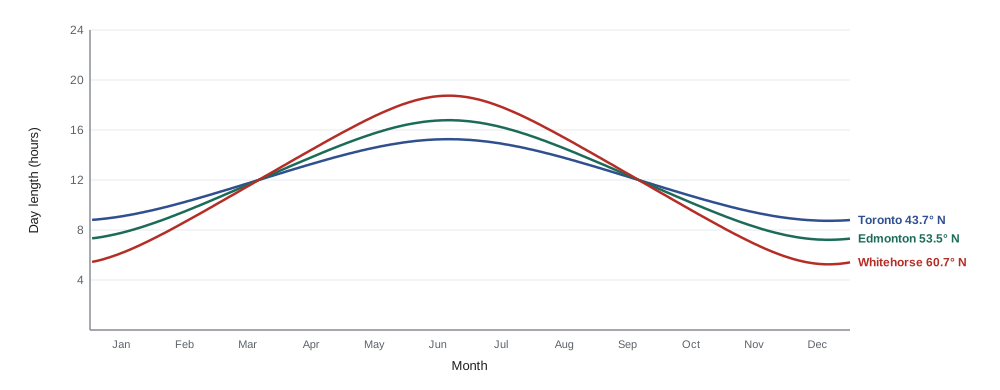
Golden hour at high latitudes
The time the sun spends in the band of low elevations that photographers call golden hour, roughly from the horizon to about 6 degrees up, depends on how steeply its path crosses the horizon. At the equator around the equinox, the sun climbs about 15 degrees an hour, so it passes through the first 6 degrees in about 24 minutes. At higher latitudes, the path is tilted, and the climb rate near the horizon at the equinox is roughly \( 15 \cos\varphi \) degrees per hour.
Worked problem
Golden hour length at the equinox
Estimate how long the sun takes to climb from 0 to 6 degrees at the equinox at latitude 45° N and at 60° N.
Show solution
- At 45°: climb rate ≈ 15 × cos 45° = 15 × 0.707 ≈ 10.6 degrees per hour.
- Time for 6 degrees: 6 / 10.6 ≈ 0.57 hours ≈ 34 minutes.
- At 60°: climb rate ≈ 15 × cos 60° = 7.5 degrees per hour.
- Time for 6 degrees: 6 / 7.5 = 0.8 hours = 48 minutes.
Answer: About 34 minutes at 45° N and 48 minutes at 60° N. Near the solstices at high latitudes the sun's path is even shallower, so in midwinter in the North the sun can stay in this low band for hours, and in midsummer it may skim the horizon around midnight.
Mountains, forests and cliffs change these numbers locally. A valley floor may lose direct sun long before astronomical sunset, while a summit may catch the first and last light. Planning tools that show the terrain horizon are essential in mountain country.
Weather: forecasting the conditions that make pictures
Clear blue skies are rarely the best for landscapes. Photographers look for weather that creates interest: broken cloud that catches colour at sunrise and sunset, clearing storms, fog, mist, fresh snow, frost and dramatic light breaking through. Learning to read forecasts and imagery greatly improves the odds.
- Cloud cover by level. Many forecasts break cloud into low, middle and high layers. High and mid-level clouds, such as cirrus and altocumulus, often light up at sunrise and sunset if the horizon in the direction of the sun is clear, so the low sun can reach them. Thick low cloud on the sun's side usually blocks colour.
- Fog and mist. Radiation fog forms on clear, calm nights when the ground cools and the air near it reaches its dew point, especially in valleys and over water in autumn. A forecast of clear skies, light wind and a small gap between temperature and dew point overnight suggests fog by dawn.
- Clearing storms. The edge of a passing storm often brings dramatic light, rainbows and fresh snow. Satellite and radar images help you time the clearing.
- Frost and hoar frost. Clear, cold, calm nights with high humidity produce frost; hoar frost forms when water vapour freezes directly onto surfaces.
- Smoke and haze. Wildfire smoke, increasingly common in summer across western and northern North America, can produce deep red suns but also flat, grey scenes and serious health hazards (Lesson 11).
Worked problem
Will there be fog?
An evening forecast for a river valley gives an air temperature of 9 °C falling to a low of 3 °C before dawn, a dew point of 4 °C, clear skies and wind under 5 km/h. Is valley fog likely at sunrise?
Show solution
- Fog forms when the air cools to its dew point.
- The forecast low (3 °C) is below the dew point (4 °C), so the air near the ground should reach saturation.
- Clear skies allow strong radiative cooling, and light wind lets the cool air settle in the valley.
- Rivers add moisture near the surface.
Answer: Yes, conditions favour radiation fog by dawn. A good plan is a viewpoint above the valley to shoot fog filling it at sunrise, with a backup position in the fog for moody forest scenes.
Tides
On coasts, the tide controls what is visible and what is safe. Low tide may reveal tide pools, sea stacks and reflective sand; high tide may bring waves crashing against rocks or cut off a beach entirely. Tide tables give the times and heights of high and low water for each port, and tidal ranges vary enormously. The Bay of Fundy between Nova Scotia and New Brunswick has the highest tides in the world, with ranges up to about 16 m in the Minas Basin, while some coasts have ranges under a metre.
Between high and low water, the tide does not rise or fall at a steady rate. A rough guide called the rule of twelfths divides the roughly six hours between high and low water into six equal parts. In the first hour the tide changes by one twelfth of its range, then two twelfths, three, three, two and one. The middle two hours change fastest, which is when a beach can flood quickly.
Worked problem
Timing a tide-pool shoot
Low tide is at 07:00 with a range of 6.0 m to the previous high tide. A photographer wants the water at least 4 m below high water to reach a rock shelf. Using the rule of twelfths, between what times is the shelf accessible around this low tide?
Show solution
- Water must be at least 4 m below high water, that is, within 2 m of low water.
- Counting back from low tide: the last hour before low changes 1/12 of 6 m = 0.5 m; the hour before that 2/12 = 1.0 m. Two hours before low, the water is 1.5 m above low; three hours before, 1.5 + 1.5 = 3.0 m above low.
- So the 2 m mark is reached between two and three hours before low: 2 m is 0.5 m into the 1.5 m third hour, about one third of the way, so about 2 hours 20 minutes before low, at about 04:40.
- By symmetry, the water rises back above 2 m about 2 hours 20 minutes after low, at about 09:20.
Answer: About 04:40 to 09:20. In practice, add a generous safety margin, check the local tide table and watch for waves and surges, because the rule of twelfths is only approximate and some places, including parts of the Bay of Fundy, flood very fast.
| Hour after high water | Fraction of range | Cumulative fall (6 m range) |
|---|---|---|
| 1 | 1/12 | 0.5 m |
| 2 | 2/12 | 1.5 m |
| 3 | 3/12 | 3.0 m |
| 4 | 3/12 | 4.5 m |
| 5 | 2/12 | 5.5 m |
| 6 | 1/12 | 6.0 m |
Forecasting the aurora
The aurora borealis appears when charged particles from the sun, carried by the solar wind, interact with Earth's magnetic field and upper atmosphere. It is most often seen in a ring, the auroral oval, centred on the magnetic pole, which passes over northern Canada and Alaska. Much of northern Canada sees the aurora on many clear nights; southern Canada and the northern United States see it during stronger geomagnetic activity.
Forecasters use the Kp index, a scale from 0 to 9 that measures global geomagnetic disturbance over three-hour periods. Higher values push the auroral oval farther from the pole. As a very rough guide, Kp 3 to 4 often brings aurora to much of the Canadian Prairies and northern regions, while Kp 6 or more may make it visible across southern Canada and the northern United States, and major storms have brought it much farther south, as happened in May and October 2024. Short-term forecasts based on real-time solar wind measurements from spacecraft give about 30 to 60 minutes' warning and are more useful than multi-day forecasts. In Canada, the Canadian Space Weather Forecast Centre at Natural Resources Canada issues forecasts; in the United States, the NOAA Space Weather Prediction Center does.
Even with a good forecast, you need clear, dark skies away from city lights and a view to the north. Lesson 7 covers how to photograph the aurora once it appears.
Seasonal and natural events
Many of the best nature subjects happen only in short windows: autumn colour, spring wildflowers, bird migrations, salmon runs, elk rut, ice formations and northern lights seasons. Building a personal calendar of these events makes planning easier. Local naturalist groups, parks agencies, phenology networks and citizen-science projects publish timings, which shift from year to year with weather and are changing with climate.
| Event | Typical timing (varies by region) | Notes |
|---|---|---|
| Spring migration of waterfowl | March to May | Wetlands, staging areas |
| Prairie and alpine wildflowers | June to August | Higher elevations later |
| Autumn colour in eastern forests | Late September to mid-October | Earlier in the north and at elevation |
| Larch colour in the Rockies | Mid to late September | Often only one to two weeks |
| Elk rut | September to October | Keep large distances: bulls are aggressive |
| Aurora season | Late August to April at high latitudes | Needs dark skies; equinox months often active |
Backup plans and decision rules
Weather rarely does exactly what was forecast. A good plan includes a primary location and one or two backups suited to different conditions: a wide vista if the sky is interesting, a forest or waterfall if it is overcast, an intimate scene if wind or rain ruins the main plan. Many photographers also set simple decision rules, such as leaving for a sunrise location only if the cloud forecast for the eastern horizon is below a threshold, or switching to a sheltered location if the wind forecast is above a certain speed.
Finally, factor in travel time, hiking time in the dark, parking and access rules, and a margin. Arriving 45 to 60 minutes before sunrise lets you find your composition, set up and catch the pre-dawn colour, which is often better than the sunrise itself.
Common mistakes
MistakeUsing sunrise times for a flat horizon in a mountain valley.
InsteadCheck the terrain horizon; local sunrise may be much later.
MistakeHoping for colour because the sky is cloudy overhead.
InsteadCheck whether the horizon toward the sun is clear enough for low light to reach the clouds.
MistakeTreating the rule of twelfths as precise.
InsteadUse it as a rough guide, check local tide tables and add a large safety margin.
MistakeRelying on multi-day aurora forecasts.
InsteadUse short-term solar wind data and watch the sky; conditions change quickly.
MistakeHaving no backup when the forecast fails.
InsteadPlan alternative locations for different conditions and set decision rules.
Summary and key terms
- Planning is a loop: research, scout, predict, shoot and review.
- Day length follows \( \cos H_0 = -\tan\varphi \tan\delta \); seasonal swings grow with latitude.
- At high latitudes the sun climbs slowly, so golden light and twilight last much longer.
- Forecasts by cloud level, dew point, wind and satellite imagery help predict colour, fog and clearing storms.
- The rule of twelfths approximates tidal change; the middle hours change fastest.
- The Kp index and real-time solar wind data help forecast the aurora.
- Seasonal event calendars and backup plans with decision rules improve the odds.
Practice problems
Work each problem on paper first, then reveal the answer to check.
List the five steps of the planning loop.
Show answer
Research, scout, predict, shoot, review.
At latitude 50° at the equinox, about how fast does the sun climb near the horizon?
Show answer
15 × cos 50° ≈ 9.6 degrees per hour.
How long does that sun take to rise 6 degrees?
Show answer
6 / 9.6 ≈ 0.63 hours, about 38 minutes.
Why might sunrise in a valley be later than the app says?
Show answer
The terrain horizon blocks the sun until it climbs higher.
What forecast clues suggest fog at dawn?
Show answer
Clear skies, light wind and a low temperature at or below the dew point.
Using the rule of twelfths, how much does a 4.8 m tide fall in the third hour?
Show answer
3/12 × 4.8 = 1.2 m.
Which hours of a tide change fastest?
Show answer
The third and fourth hours.
What does a higher Kp value mean for aurora watchers farther south?
Show answer
The auroral oval expands, so the aurora may be visible farther from the pole.
Why arrive 45 to 60 minutes before sunrise?
Show answer
To find and set up the composition and catch pre-dawn colour.
Give one backup for an overcast morning.
Show answer
A forest, waterfall or intimate scene that benefits from soft light.
Lesson quiz · 5 questions
Score 60% or more to complete this lesson.
Create a free account to save your progress, take quizzes and earn a certificate.