
PHOT-350 · Lesson 1 of 12 · 31 min
Aerial imaging past and present
Photographs taken from above change how we see places. A field that looks flat and ordinary from the road becomes a pattern of rows and textures from 100 metres up. A shoreline becomes a line drawing of sand, water and foam. A city block becomes a diagram of roofs, shadows and traffic. For most of photography's history, getting a camera into the air was expensive, dangerous or both, so aerial images were made by specialists for armies, governments, surveyors and newspapers. Small camera drones changed that within about fifteen years. Today a photographer can carry a capable aircraft in a backpack, fly it within minutes of arriving on site and come home with stills, video, maps and 3-D models. This course treats the drone as a serious imaging tool: one that needs regulation, planning, flying skill, photographic judgment and an understanding of mapping. This first lesson traces where aerial imaging came from, what drones are used for today and what kind of professional the work requires.
Before drones: kites, balloons and aircraft
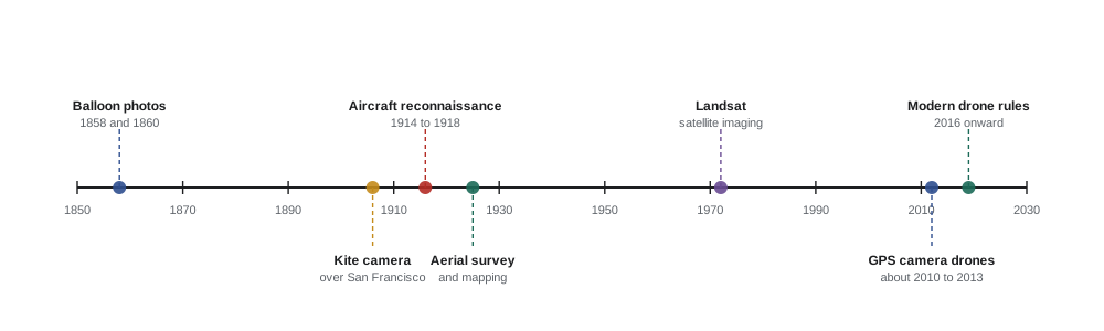
The first aerial photographs were made from balloons. In 1858 the French photographer known as Nadar took pictures of the village of Petit-Bicêtre from a tethered balloon, using the wet collodion process, which meant coating, exposing and developing glass plates inside the basket. None of those first images survives. The oldest surviving aerial photograph is generally said to be James Wallace Black's 1860 view of Boston from a balloon about 600 metres up, which he titled 'Boston, as the Eagle and the Wild Goose See It'. Balloon photography was slow and depended on the weather, but it showed that the view from above held information no ground photograph could give.
Kites came next. In the 1880s and 1890s experimenters lifted small cameras on kites and triggered them with slow-burning fuses or a line from the ground. In 1906 the American photographer George Lawrence used a train of kites to lift a large panoramic camera above San Francisco a few weeks after the earthquake and fire, producing a famous image of the ruined city. Pigeons carrying tiny timed cameras were even tried in Germany around 1908. These experiments matter because they solved the same problems drone photographers still solve: how to get a camera to a chosen height and angle, keep it steady, trigger it at the right moment and bring it back safely.
Powered aircraft made aerial photography practical at scale. During the First World War both sides photographed trenches and artillery positions from aircraft, and by 1918 reconnaissance units were producing thousands of prints a day. After the war, the same cameras and skills moved into civilian mapping. In Canada, aerial survey grew quickly because of the country's size: bush planes photographed forests, lakes and the North for maps, forestry and resource exploration, and the national air photo collection now holds millions of images going back to the 1920s. In the United States, federal agencies photographed farmland in the 1930s for soil conservation and crop programs, building archives that historians and land managers still use. Mapping cameras became precise instruments, with calibrated lenses, film flattened against glass and fiducial marks so that measurements could be taken directly from the prints. This is the origin of photogrammetry, the science of measuring from photographs, which lesson 8 covers.
Aerial photography also shaped journalism and art. Newspapers hired planes to photograph floods, fires and crowds. Photographers such as Margaret Bourke-White worked from aircraft for magazines, and later artists made aerial views a genre of their own, using the abstraction of the view from above to show patterns of agriculture, industry and nature. Satellites added a further layer from the 1960s onward, first for intelligence and weather, then for civilian Earth observation. Landsat, launched in 1972, began a continuous record of the planet's surface that scientists still use to track forests, cities and ice. Canada's RADARSAT satellites, starting in 1995, used radar to image the surface through cloud and darkness, which mattered for ice monitoring in the Arctic.
The drone era
Military uncrewed aircraft existed for decades before civilian drones, but three developments made small camera drones possible around 2010. The first was cheap, accurate sensors from smartphones: tiny accelerometers, gyroscopes, magnetometers and barometers that let a flight controller hold an aircraft level and steady. The second was satellite positioning small and cheap enough to fit in a toy, which allowed position hold, automatic return to the launch point and pre-planned routes. The third was lithium-polymer batteries and efficient brushless motors, which gave useful flight times. Add a stabilized camera on a motorized gimbal and a live video link to the pilot's phone or controller, and the modern photography drone appeared.
Early hobby multirotors were built from kits and needed constant attention to fly. Within a few years, ready-to-fly drones with integrated cameras could hover hands-free, avoid some obstacles and come home when the battery ran low. Image quality rose quickly, from small video sensors to one-inch and larger sensors that can shoot raw stills and log video. At the same time, regulators began to treat drones as aircraft. The United States introduced its small drone rule, Part 107, in 2016. Canada's comprehensive rules for drones from 250 grams to 25 kilograms took effect on June 1, 2019, and were expanded on November 4, 2025, to allow some beyond-visual-line-of-sight work and larger drones. Lesson 3 explains these rules in detail.
What drones are used for today
Drone imaging now spans many industries. A working photographer may do several of these, and specialists build whole businesses around one.
| Use | Typical outputs | Main skills needed |
|---|---|---|
| Real estate and architecture | Exterior stills, context views, short video | Composition, light timing, local airspace knowledge |
| Weddings, events and tourism | Establishing shots, group images, promotional video | People safety, distance rules, smooth flying |
| Film and advertising | Cinematic moving shots, reveals, tracking | Precise flying, crew coordination, permits |
| Mapping and surveying | Orthomosaics, elevation models, volumes | Photogrammetry, ground control, accuracy checks |
| Construction progress | Repeated views, site maps, 3-D models | Consistent missions, data management |
| Inspection | Close-up stills of roofs, towers, bridges, solar farms | Close flying, thermal imaging, reporting |
| Agriculture and environment | Multispectral maps, plant health indices | Sensor calibration, timing, analysis |
| Journalism and documentary | News images, context aerials | Ethics, privacy, fast deployment |
| Public safety | Search, scene documentation, situational awareness | Thermal imaging, coordination with responders |
Two broad kinds of work run through this list. Pictorial work aims at images people will look at for their beauty, information or emotion: a cabin on a lake at sunrise, a wedding party arranged in a heart shape on a beach, a reveal shot rising over a forest. Measurement work aims at data: a map accurate to a few centimetres, a stockpile volume, a thermal image showing a failed solar panel. The same aircraft can do both, but the planning is different. Pictorial work chooses angle, light and moment; measurement work chooses altitude, overlap, ground control and processing settings. This course teaches both, because clients increasingly ask photographers for maps and models as well as pictures.
Why the aerial view is powerful
Aerial images work for several reasons. They show context: a house in relation to its lot, its street, the lake and the town. They reveal pattern: rows of crops, the geometry of a parking lot, the branching of a river delta. They change scale: people become small figures in a landscape, and familiar places look new. They allow measurement: from a map made of overlapping vertical photographs, one can measure distances, areas and volumes. And they offer access: a drone can look at the top of a cell tower or the underside of a bridge without anyone climbing.
These strengths come with responsibilities. A camera in the sky can see into backyards and windows, disturb wildlife, frighten people and, if flown carelessly, fall on someone. The same rules that let professionals work exist because drones can hurt people and aircraft. A professional aerial photographer is therefore part pilot, part photographer, part data technician and part diplomat, explaining what they are doing to neighbours, landowners and the public.
The professional aerial photographer
Clients hiring a drone photographer expect more than a person who owns a drone. They expect someone who holds the right certificate, has insurance, knows the airspace, plans for weather and risk, flies smoothly and safely, captures usable images the first time, processes them correctly and delivers files in the right format with the right licence. That list maps directly onto this course:
- lessons 2 to 5 cover the aircraft, the rules, airspace, planning and flying safely;
- lessons 6 and 7 cover composition, light and techniques for stills and video;
- lessons 8 and 9 cover mapping, photogrammetry and specialized sensors;
- lessons 10 and 11 cover privacy, ethics, community relations and running a business;
- lesson 12 brings everything together in a complete project plan.
This course is not a pilot certificate course. It explains the rules and the knowledge behind them, but to fly legally you must pass the exams and any flight review your regulator requires. Think of this course as the photographer's and mapper's companion to that training.
Pictorial and measurement thinking
A useful habit is to ask, at the start of every job, whether the client mainly needs pictures or measurements. Consider two requests for the same farm. A tourism board wants images of the farm's sunflower field for a brochure. The photographer will wait for a clear evening, fly low at an oblique angle to show the flowers against the setting sun, and perhaps include a visitor walking along a path for scale. A seed company wants to know how many plants survived a frost. The photographer will fly a grid at a fixed altitude in even midday light with high overlap, possibly with a multispectral sensor, and deliver an orthomosaic and a plant count. The aircraft might be the same; almost every other decision differs.
Mixed jobs are common. A construction client may want a monthly progress map for engineers and a few attractive oblique stills for the website. A real estate client may want marketing images plus a simple measured site plan. Planning both outputs into one visit saves time, but the mission must be designed so neither is compromised, for example by flying the mapping grid first while the light is even and then taking pictorial images as the light warms.
Satellites, aircraft and drones compared
Drones are not always the right tool. Satellites cover huge areas cheaply and repeatedly but at coarser resolution and with cloud problems; even the best commercial satellite images show detail of roughly 30 centimetres, and the client cannot choose the exact time. Crewed aircraft cover large areas at high resolution and can fly where drones cannot, but cost far more per flight. Drones excel at small to medium areas, very high resolution, flexible timing and low cost per job. A drone mapping a 20-hectare site might resolve detail of 2 centimetres or better, something no satellite can match, but mapping a whole county by drone would take months.
| Platform | Area per day | Typical ground detail | Strengths | Limits |
|---|---|---|---|---|
| Satellite | Thousands of km² | About 0.3 to 30 m | Huge coverage, archives, repeat visits | Cloud, fixed timing, coarser detail |
| Crewed aircraft | Hundreds of km² | About 5 to 30 cm | Large areas at high detail | High cost, scheduling, airspace |
| Drone | A few km² at most | About 0.5 to 5 cm | Very high detail, flexible, low cost | Small areas, weather, visual line of sight rules |
Worked problem
Choosing a platform
A municipality wants an up-to-date image of a 15-hectare park redevelopment, with detail fine enough to see individual paving stones about 10 cm across. It also wants an image of the entire 400 km² municipality for a planning report. Which platforms fit each request?
Show solution
- Paving stones 10 cm across need ground detail of a few centimetres, so the park needs roughly 2 to 3 cm per pixel.
- A drone can map 15 hectares at 2 cm per pixel in well under a day, so the park is a drone job.
- The 400 km² image needs moderate detail over a very large area. A drone would need hundreds of flights.
- Recent satellite imagery or a crewed aerial survey fits the municipality-wide image.
Answer: Use a drone for the park and satellite or crewed aircraft imagery for the whole municipality.
Worked problem
Estimating how much a view from above reveals
A photographer flies at 100 m altitude with a camera whose horizontal field of view is 74 degrees, pointing straight down. About how wide is the strip of ground in each frame?
Show solution
- For a straight-down camera, ground width = 2 × altitude × tan(field of view ÷ 2).
- Half the angle is 37 degrees, and tan 37° ≈ 0.754.
- Width ≈ 2 × 100 × 0.754 ≈ 151 m.
Answer: About 150 m of ground across each frame.
In this equation, \( W \) is the width of ground covered, \( h \) is the height above ground and \( \theta \) is the camera's field of view across that width. Lesson 8 refines this into ground sample distance, the size of ground represented by a single pixel, which is the basic measure of detail in drone mapping.
How the drone changed the photographer's job
Before drones, a photographer who wanted an aerial view hired a plane or helicopter, booked a pilot and flew for an hour at hundreds of dollars or more. Every frame was precious, and low, slow viewpoints between rooftop and aircraft heights were almost impossible. Drones opened that middle zone, from a few metres to around 120 metres, and made it cheap to experiment. They also changed workflows: an aerial photographer may now shoot hundreds of frames per flight, stitch panoramas automatically, deliver 3-D models and live-stream video to clients. With that ease came risk: many people fly without understanding airspace, privacy or safety, and some high-profile incidents near airports and emergency scenes led to stricter rules and public suspicion. Professionals who follow the rules, communicate clearly and fly well help keep that public trust.
The rest of the course builds the knowledge to work at that standard. The next lesson looks inside the aircraft: frames, motors, batteries, cameras, gimbals and the specialized sensors that turn a flying camera into a measuring instrument.
Common mistakes
MistakeTreating a drone as a flying toy rather than an aircraft.
InsteadLearn and follow aviation rules, plan every flight and fly with an aviator's caution.
MistakeAssuming a drone is always the best aerial tool.
InsteadMatch the platform to the area and detail needed; satellites and aircraft suit large areas.
MistakePlanning a mapping job like a photo shoot.
InsteadDecide early whether the client needs pictures, measurements or both, and plan altitude, overlap and light accordingly.
MistakeIgnoring the history of aerial survey.
InsteadUse national air photo archives for before-and-after comparisons and context.
MistakeThinking regulations are only for large commercial operators.
InsteadKnow that registration, certification and operating rules apply to almost every drone used for paid work.
Summary and key terms
- Aerial photography began with balloons in 1858, then kites, aircraft and satellites.
- Aircraft photography in the world wars led to aerial survey and photogrammetry, measuring from photographs.
- Cheap sensors, satellite positioning, lithium batteries and gimbals made small camera drones practical around 2010.
- Drones now serve real estate, events, film, mapping, construction, inspection, agriculture, journalism and public safety.
- Pictorial work chooses angle, light and moment; measurement work chooses altitude, overlap, ground control and processing.
- Drones suit small areas at very high detail; satellites and crewed aircraft suit large areas.
- Professional aerial photographers combine piloting, photography, data handling and community relations.
Practice problems
Work each problem on paper first, then reveal the answer to check.
Who made the first aerial photographs, and how?
Show answer
Nadar, from a tethered balloon in 1858, using wet collodion plates.
Name the three technical developments that made small camera drones practical.
Show answer
Cheap motion sensors, small satellite positioning receivers, and lithium batteries with efficient brushless motors.
Give one pictorial and one measurement use of drones.
Show answer
Pictorial: real estate exteriors. Measurement: stockpile volumes or orthomosaic maps.
Why did aerial survey grow quickly in Canada?
Show answer
The country's size and remote areas made aircraft the practical way to map forests, lakes and the North.
A camera with a 70-degree field of view points straight down from 80 m. How wide is the ground strip?
Show answer
2 × 80 × tan 35° ≈ 2 × 80 × 0.700 ≈ 112 m.
When is a satellite a better choice than a drone?
Show answer
For very large areas, regular repeat coverage or historical imagery where centimetre detail is not needed.
What is the difference between a nadir and an oblique image?
Show answer
Nadir points straight down; oblique is taken at an angle.
Why must a mixed job plan the mapping and pictorial flights separately?
Show answer
Mapping needs even light, fixed altitude and overlap; pictorial work needs chosen angles and often warmer light.
What did Landsat begin in 1972?
Show answer
A continuous satellite record of the Earth's surface used to track change.
List three responsibilities that come with the aerial view.
Show answer
Respecting privacy, avoiding wildlife disturbance and flying safely around people and aircraft.
Lesson quiz · 5 questions
Score 60% or more to complete this lesson.
Create a free account to save your progress, take quizzes and earn a certificate.