
PHOT-350 · Lesson 12 of 12 · 37 min
Capstone: an aerial imaging and mapping project plan
This capstone brings the course together in one realistic project. You will plan an aerial job from the client's first enquiry to delivery: understanding the brief, classifying the operation under the rules, checking airspace and the site, assessing risk, planning photography and a mapping mission, scheduling around light and weather, organizing batteries, crew and equipment, pricing the job, handling data and privacy, and reviewing the results. The lesson works through a model project step by step and then sets out the brief and assessment criteria for your own plan. The aim is a document that a client, an insurer and a regulator would each find clear, legal and professional.
The model brief
A lakeside resort in Ontario's cottage country wants two things. First, marketing images and a short video of the main lodge, beach, docks and surrounding forest in autumn colour, for its website and social media. Second, an orthomosaic and elevation model of a 12-hectare field behind the lodge where it plans to build cabins, so its engineer can begin a concept design. The resort is about 7 km from a small public aerodrome and 3 km from a heliport used by an air ambulance. Guests will be on site, and a neighbouring cottage sits 60 m from the beach.
Before planning, the photographer clarifies the brief with the client: which images and clips matter most, what formats and sizes are needed, what accuracy the engineer needs for the site model, what coordinate system the engineer uses, when autumn colour usually peaks, who manages guests and whether the resort can give permission for take-off and landing on its property. The answers become the requirements list.
| Requirement | Source | How it will be met |
|---|---|---|
| 15 edited stills of lodge, beach, docks and forest | Marketing manager | Oblique and top-down stills at golden hour |
| 60–90 second edited video | Marketing manager | Planned moves: reveal, orbit, fly-over, top-down rise |
| Orthomosaic and DSM of the site | Engineer | Mapping mission at about 2 cm GSD |
| Absolute accuracy about 5 cm horizontal | Engineer | RTK drone plus 5 check points surveyed by the engineer's surveyor |
| No identifiable guests in marketing images without consent | Resort and privacy law | Schedule around guests; use models with releases; blur |
| Delivery within 10 days of flying | Client | Processing and editing schedule |
Step 1: classify the operation
The photographer first decides which rules apply and what certificate, authorization or waiver is needed. For each part of the job, the questions are: what does the drone weigh, what airspace is it in, how close will it be to people, will it fly over people, is it within visual line of sight, and is it day or night?
The drone weighs 900 g, so it must be registered and flown by a certified pilot. The NAV Drone app and NRC Drone Site Selection Tool show the site is in uncontrolled Class G airspace below 122 m, outside the aerodrome's control zone. The heliport is 3 km away, beyond the 1.9 km (1 nautical mile) distance basic operations must keep from heliports, and the aerodrome is 7 km away, beyond the 5.6 km (3 nautical mile) distance from airports, so the pilot will still watch for the air ambulance helicopter. Marketing flights near the beach could come within 30 m of guests, so either the guests are kept more than 30 m away and never overflown, making it a basic operation, or the pilot uses the advanced certificate with a drone declared suitable for flight near people. The photographer holds an advanced certificate, which allows flexibility. The mapping flight over the empty field is a basic operation. No SFOC is needed.
This first step often reveals the hardest constraints. Had the resort been inside an airport's control zone, an authorization would be needed days in advance; had the client wanted flights over a crowd of guests, the plan would need different equipment, a different category or a changed concept.
Step 2: site survey and risk assessment
A desk survey using satellite images, airspace tools and the resort's site plan identifies obstacles: a 35 m (115 ft) communications mast on a hill 400 m west, tall pines up to 30 m (100 ft) around the lodge, power lines along the access road, and the docks and open water where a lost drone would sink. An on-site visit the day before confirms obstacles, finds a crane removed since the satellite image, chooses launch points clear of metal docks and away from guest paths, and identifies an emergency landing area.
The risk assessment scores the main hazards and plans mitigations. A simple matrix might rank hazards as follows.
| Hazard | Likelihood (1–5) | Severity (1–5) | Score | Mitigation |
|---|---|---|---|---|
| Guests walking under the flight path | 3 | 5 | 15 | Spotter, timing outside activities, cleared beach zone |
| Loss of drone over the lake | 2 | 3 | 6 | RTH to hover over water, conservative battery reserve |
| Medical helicopter overhead | 2 | 5 | 10 | Listen and watch; descend and land on sighting |
| Gusty wind off the lake | 3 | 3 | 9 | Wind limit of 8 m/s gusts; fly upwind of the shore |
| Compass interference near docks | 2 | 3 | 6 | Launch on grass away from metal |
| Neighbour privacy complaint | 3 | 2 | 6 | Notify neighbour; frame out the cabin; fly higher near it |
Worked problem
Setting the return-to-home altitude
The tallest obstacle on any likely return path is the pine stand at 30 m. The mast is 400 m away and 35 m tall. What RTH altitude should be set for marketing flights near the lodge?
Show solution
- Pines plus a 20 m margin: 50 m.
- The mast is off the planned area but could be passed if the drone drifts; 55 m clears it with a 20 m margin.
- Set RTH to 60 m, below the 122 m limit.
Answer: 60 m.
Step 3: plan the mapping mission
The engineer needs about 5 cm horizontal accuracy. Using the rule of thumb that horizontal accuracy is about 1 to 2 times the GSD with good control, a 2 cm GSD gives comfortable margin. The photographer's RTK mapping drone has a 13.2 mm sensor, 5,472 pixels across and an 8.8 mm lens.
Worked problem
Altitude, footprint and flight lines
Find the altitude for a 2 cm GSD, the footprint across the flight line, the line spacing at 70 percent side overlap, and the number of lines across a field 300 m wide and 400 m long.
Show solution
- Altitude h = 0.02 × 8.8 × 5,472 ÷ 13.2 ≈ 73 m (about 240 ft).
- Footprint across the line = 0.02 × 5,472 ≈ 109 m.
- Line spacing = 109 × 0.30 ≈ 33 m.
- Lines across 300 m: 300 ÷ 33 ≈ 9.1, so 10 lines plus 1 for the edge: 11 lines along the 400 m length.
Answer: Fly at about 73 m (240 ft), with 11 lines about 33 m apart.
Worked problem
Photos, time and batteries
The footprint along the line is about 73 m. With 80 percent front overlap at 7 m/s, find the photo spacing and interval, the approximate number of photos and the flight time. Each battery gives about 25 minutes, and the pilot lands at 30 percent remaining.
Show solution
- Photo spacing = 73 × 0.20 ≈ 14.6 m; interval = 14.6 ÷ 7 ≈ 2.1 s.
- Photos per 400 m line ≈ 400 ÷ 14.6 + 3 ≈ 30; total ≈ 11 × 30 = 330.
- Distance ≈ 11 × 400 + 10 × 33 ≈ 4,730 m; at 7 m/s ≈ 676 s ≈ 11 minutes; add climb, turns and margin: about 15 minutes.
- Usable battery time: 25 × 0.7 = 17.5 minutes, so one battery is enough, with a second as backup and for oblique images of the field's edges.
Answer: About 330 photos in roughly 15 minutes of flight: one battery, with a spare.
The engineer's surveyor places five check-point targets across the field and surveys them in the engineer's coordinate system before the flight. The mapping flight is scheduled for the middle of the day in consistent light, when shadows are short, and avoided on very windy days, when trees at the field's edge move and the drone's speed varies.
Step 4: plan the photography and video
Marketing images need the opposite of mapping light: low sun, long shadows and warm colour. The photographer uses a sun-position app to find when the sun lights the lodge's lake-facing facade and when it sets behind the forest. In autumn at about 45° north, sunset might be around 18:30, so golden hour runs roughly from 17:30 to 18:30, with blue hour after. The shot list names each image, its viewpoint, height, direction and time.
- High oblique of the resort in its lake and forest setting, from over the water looking back toward the lodge.
- Top-down of the docks and boats, with the line where water meets the beach.
- Low oblique of the lodge facade above the trees in warm side light.
- Video: a reveal from the dock out over the lake, an orbit of the lodge, a fly-over of the forest with a tilt down to a canoe paddled by staff models who have signed releases.
- Blue hour: the lodge with lights on, from a steady hover, with bracketing.
Worked problem
Counting batteries for the marketing shoot
The shot list needs about 8 minutes of flying for stills and 30 minutes for video takes, plus about 25 percent extra for repositioning and retakes. Each battery gives about 17 usable minutes. How many batteries are needed for one evening, and what if the first evening is cancelled?
Show solution
- Flight time: (8 + 30) × 1.25 = 47.5 minutes.
- Batteries: 47.5 ÷ 17 ≈ 2.8, so 3 batteries, with a fourth spare.
- Batteries must be recharged between golden hour and blue hour or a fifth carried.
- If cancelled, the same plan repeats on the weather day.
Answer: Four batteries, with a charger in the vehicle, plus a weather day in the contract.
Step 5: privacy, permissions and people
The resort gives written permission for take-off and landing on its property and agrees to move guests from the beach for twenty minutes at golden hour, with staff models taking their place. The photographer writes to the neighbour explaining the date, purpose and that their property will be framed out and not hovered over. Releases are signed by staff models. Any guests captured incidentally will be blurred before delivery. For the mapping flight, the field is empty, and the images will be shared only with the resort and its engineer. These steps apply the privacy and community practices from lesson 10.
Step 6: schedule, crew and equipment
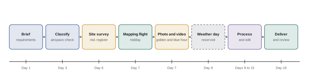
The schedule places the site visit and check-point survey a day before the main flights, the mapping flight at midday, the marketing shoot in the evening, and a weather day two days later. The crew is the pilot in command and a visual observer, who also acts as a spotter for guests and watches for the air ambulance helicopter. Equipment includes two drones (one mapping drone with RTK, one camera drone, each able to back the other up for basic tasks), batteries, chargers, ND filters, landing pads, high-visibility vests, a first aid kit, a fire-resistant battery bag, signs with the operator's contact details, and copies of certificates, registration, insurance and permissions.
Step 7: price the job
Worked problem
Building the quote
The photographer estimates: planning, airspace checks and client calls 3 h; site visit 3 h; mapping flight day 3 h; marketing shoot evening 4 h; mapping processing and accuracy report 4 h; photo and video editing 10 h; delivery and meeting 1 h. Her rate is $85 an hour, fixed costs are $180 per job day for two days, travel costs $120, and she adds $15 for weather risk. What is the price before tax?
Show solution
- Hours: 3 + 3 + 3 + 4 + 4 + 10 + 1 = 28 h.
- Time: 28 × 85 = $2,380.
- Fixed costs: 2 × 180 = $360.
- Total: 2,380 + 360 + 120 + 15 = $2,875.
Answer: About $2,875 before tax, which she might present as a marketing package and a mapping package so the client can see each part's value.
The contract states the deliverables and accuracy target, the licence for marketing use, that the resort will own the mapping data, the weather day policy, the pilot's authority to cancel for safety, who obtains permissions, how bystanders are handled, insurance, payment terms and the deposit (lesson 11).
Step 8: fly, process, deliver and review
On the day, the crew follows the checklists, confirms weather and NOTAMs, briefs resort staff and models, and records each flight. After the mapping flight, the photographer checks image count, sharpness and coverage on site before leaving. Processing produces the orthomosaic, DSM and an accuracy report from the check points. Editing produces the stills and video. Files are delivered through a secure link with a short report describing the methods, settings, accuracy and any limitations. A post-project review notes what went well, what to change and any incidents or near misses.
Worked problem
Checking the map's accuracy
The five check points show horizontal differences of 2.4, 3.1, 1.9, 2.8 and 3.6 cm. Does the map meet the 5 cm target?
Show solution
- Squares: 5.76, 9.61, 3.61, 7.84, 12.96; sum 39.78.
- Mean square: 39.78 ÷ 5 = 7.96.
- RMSE = √7.96 ≈ 2.8 cm.
Answer: Horizontal RMSE ≈ 2.8 cm, comfortably within the 5 cm target. The report states the method and number of check points.
Your capstone brief and assessment
Plan your own aerial imaging project for a real or realistic client. It must include at least one photography or video component and one mapping or specialized imaging component (for example thermal, multispectral or inspection). Your plan should contain:
- the client brief and a requirements table;
- classification of the operation under the rules for your country, with the certificate, authorizations or waivers needed;
- a site survey with airspace, obstacles and people, and a risk register with mitigations;
- a mapping or specialized mission plan with altitude, GSD, overlap, line spacing, photo count, time and batteries;
- a photography and video shot list tied to sun position and time;
- privacy, permissions, community relations and data handling;
- schedule, crew, equipment and checklists;
- a quote and key contract terms;
- a delivery and review plan, including how accuracy or quality will be checked.
| Criterion | Weight | What strong work shows |
|---|---|---|
| Legality and classification | 20 % | Correct category, certificates and authorizations, with sources checked |
| Safety and risk management | 20 % | Realistic hazards, scores, mitigations, RTH and weather limits |
| Technical planning | 20 % | Correct GSD, overlap, flight lines, timing and battery calculations |
| Creative plan | 15 % | A shot list that tells a story and uses light deliberately |
| Privacy, ethics and community | 10 % | Permissions, notices, releases and data handling |
| Business and communication | 15 % | A justified quote, contract terms and a clear client-ready document |
Common mistakes
MistakeStarting with creative ideas before checking airspace and the rules.
InsteadClassify the operation first, because it sets the hard constraints.
MistakePlanning mapping and marketing flights for the same time of day.
InsteadMap in consistent midday light and shoot marketing images in low, warm light.
MistakeBringing just enough batteries for the plan.
InsteadAdd retakes, repositioning, a spare and charging time.
MistakeForgetting neighbours and guests until the day of the shoot.
InsteadArrange permissions, notices, models and releases in advance.
MistakeDelivering a map without stating its accuracy.
InsteadReport check-point RMSE, methods and limits with the deliverables.
Summary and key terms
- A professional aerial project starts with a clear brief turned into measurable requirements.
- Classifying the operation under the rules comes first and sets the main constraints.
- Site surveys and risk registers identify hazards and mitigations, including RTH altitude.
- Mapping missions are planned from accuracy needs through GSD, overlap, lines, photos and batteries.
- Photography and video are planned around sun position, with a shot list and battery count.
- Privacy, permissions, crew, equipment, quotes and contracts are part of the plan.
- Delivery includes accuracy checks, clear reporting and a post-project review.
Practice problems
Work each problem on paper first, then reveal the answer to check.
Why is classifying the operation the first planning step?
Show answer
It sets the legal limits, certificates and authorizations the whole plan must respect.
A client needs 4 cm horizontal accuracy. What GSD would you aim for?
Show answer
About 2 cm, giving accuracy of roughly 1 to 2 times GSD with good control.
What altitude gives a 2.5 cm GSD with a 13.2 mm sensor, 5,472 pixels and an 8.8 mm lens?
Show answer
0.025 × 8.8 × 5,472 ÷ 13.2 ≈ 91 m.
Footprint 110 m, side overlap 75 percent: what line spacing?
Show answer
27.5 m.
Why fly mapping at midday and marketing at golden hour?
Show answer
Mapping needs consistent light and short shadows; marketing benefits from warm, low light.
A shot list needs 40 minutes of flying plus 25 percent extra with 15 usable minutes per battery. How many batteries?
Show answer
50 ÷ 15 ≈ 3.3, so 4 plus a spare.
Name three items for a crew equipment list.
Show answer
Spare batteries, vests, first aid kit, fire-resistant battery bag, landing pads, documents.
What should a delivery report for a map include?
Show answer
Methods, settings, coordinate system, check-point accuracy and limitations.
Errors of 3, 3, 4 and 2 cm at check points give what RMSE?
Show answer
√((9+9+16+4)/4) ≈ 3.1 cm.
Why include a post-project review?
Show answer
To learn from what worked and record incidents or near misses for next time.
Lesson quiz · 5 questions
Score 60% or more to complete this lesson.
Create a free account to save your progress, take quizzes and earn a certificate.