
PHOT-350 · Lesson 11 of 12 · 31 min
The aerial imaging business
Many photographers buy a drone to add aerial shots to their existing work; others build a whole business around aerial imaging, mapping or inspection. Either way, drone work has costs and risks that ground photography does not: aircraft that crash or become obsolete within a few years, certification and recurrent training, insurance with aviation exclusions, airspace authorizations, weather cancellations and liability for damage to people and property. Clients also need educating about what drones can and cannot legally do. This lesson covers the main markets for aerial imaging, how to price work from the real cost of operating, insurance, contracts and weather clauses, licensing images and data, taxes, marketing and how to grow a sustainable aerial imaging practice. It builds on the business lessons in earlier photography courses rather than repeating them.
Markets for aerial imaging
Aerial work spans many markets, each with its own expectations, budgets and competition.
- Real estate and architecture: exterior stills and short videos of homes, commercial property and land. High volume, fast turnaround, price-sensitive at the low end, better paid for luxury and commercial work (see PHOT-311).
- Construction and development: progress photos, video and maps on a regular schedule, often monthly or weekly. Repeat work, with accuracy and consistency valued.
- Events and weddings: venue overviews and moments within the rules on flying near people (see PHOT-340).
- Tourism, hospitality and destination marketing: resorts, golf courses, parks and towns. Strong emphasis on beautiful light and storytelling.
- Inspection and asset management: roofs, solar, towers, bridges and industrial sites (lesson 9). Higher rates, specialized training and insurance, safety requirements.
- Mapping and agriculture: orthomosaics, volumes, crop health (lessons 8 and 9). Often sold per area or per project with software subscriptions.
- Film, television and advertising: aerial cinematography under production schedules and strict safety rules (see CINE-410).
- Stock imagery and footage: aerial images licensed through stock agencies or direct sales.
Choosing two or three markets that suit the photographer's skills, location and equipment usually works better than trying to serve everyone. A construction mapping client and a wedding couple need different drones, software, insurance and marketing.
The real cost of operating a drone
Drone work looks cheap because a capable camera drone costs less than a professional camera body. But the aircraft is consumed faster: it can crash, be lost over water, be replaced by a model with better sensors or safety features, or become non-compliant with new rules. Professionals plan to replace small drones every two to three years and keep a backup aircraft so a crash does not cancel the next job.
Worked problem
Working out the cost of doing business
A part-time aerial photographer owns two drones costing $3,000 each, replaced every 3 years, plus batteries and accessories of $1,500 per year. Insurance is $1,200 a year, software and subscriptions $900, training and certification $300, and marketing and website $1,100. She expects 60 jobs a year, each with about $40 in travel and $25 in other variable costs. What does each job cost before paying herself?
Show solution
- Drone depreciation: 2 × $3,000 ÷ 3 = $2,000 a year.
- Fixed costs: 2,000 + 1,500 + 1,200 + 900 + 300 + 1,100 = $7,000 a year.
- Fixed cost per job: 7,000 ÷ 60 ≈ $117.
- Variable costs: 40 + 25 = $65.
- Total cost per job ≈ $182.
Answer: About $182 per job before any pay for her time. If a typical job takes 4 hours including travel and editing and she wants $60 an hour, the minimum price is about 182 + 240 = $422.
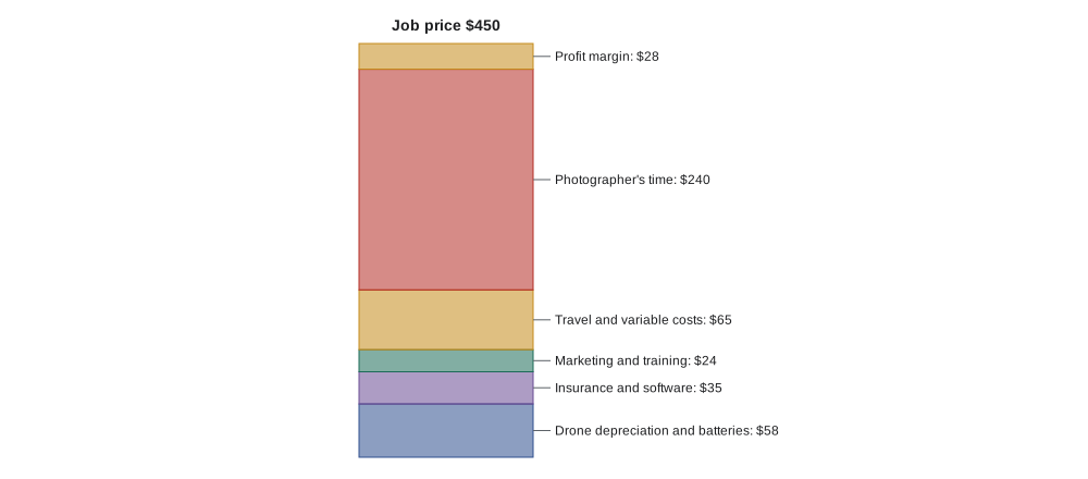
Pricing models vary by market. Real estate photographers often charge per property or package. Construction and mapping work may be priced per visit, per hectare or acre, or as a monthly subscription. Inspection often uses day or half-day rates plus reporting time. Film work uses day rates for pilot, camera operator and visual observer, plus equipment rental. Whatever the model, the price must cover the full cost of operating, unpaid time spent on planning, airspace authorizations and processing, and a margin for weather days and reshoots.
Worked problem
Pricing a mapping service by area
A mapping operator can map about 40 hectares per battery and uses 3 batteries per site visit, plus 2 hours of planning and travel and 3 hours of processing and quality checks. Fixed costs come to $200 per visit and she charges $85 an hour for her time. What price per hectare covers a typical 100-hectare site?
Show solution
- Flight time: 100 ha ÷ 40 ha per battery = 2.5 batteries; with set-up, about 1.5 hours on site.
- Total time: 2 + 1.5 + 3 = 6.5 hours × $85 = $552.50.
- Add fixed costs: 552.50 + 200 = $752.50.
- Per hectare: 752.50 ÷ 100 ≈ $7.50.
Answer: About $7.50 per hectare, with a minimum charge so that small sites still cover travel and set-up.
Insurance
Insurance is essential for professional drone work. Liability insurance covers claims if the drone injures someone or damages property; clients, venues, municipalities and film productions commonly require proof of $1 million to $5 million in coverage and may ask to be named as additional insureds. Hull insurance covers damage to or loss of the drone and its camera. Payload and equipment coverage extends to cameras and sensors. Ordinary business or homeowner policies usually exclude aircraft, including drones, so a specific aviation or drone policy is needed.
Policies have conditions. Most cover only flights that comply with aviation rules, flown by certified pilots named on the policy, within the stated territory and uses. A flight in a closed airspace or without the required certificate may be excluded, leaving the operator personally liable. Hourly or on-demand insurance is available for occasional operators, while full-time businesses usually buy annual policies.
Canadian aviation rules do not generally require liability insurance for small drones flown under the basic or advanced rules, though special flight operations certificates and some operations may set insurance conditions. In practice, clients, venues and municipalities require it, and it is commonly arranged through aviation insurance brokers.
Contracts for aerial work
A written contract protects both sides and educates the client. In addition to the usual photography terms, aerial contracts should cover:
- Scope and deliverables: the shots, maps or reports, formats, resolution, accuracy targets for mapping, and delivery dates.
- Airspace, permissions and permits: who obtains landowner, park or municipal permission; that flights depend on airspace authorization; and what happens if authorization is refused.
- Weather and safety: that the pilot in command decides whether flying is safe and legal, with weather days or rescheduling at no penalty, and a fee for a second visit if the client changes the date.
- Privacy: who notifies neighbours or tenants, and that bystanders may be blurred or excluded.
- Licence and data ownership: what the client may do with images, video and data (lesson 9 and below), and whether the operator may use them for marketing.
- Liability and indemnity: limits of liability, insurance, and responsibility for site conditions and information supplied by the client, such as obstacle heights or underground utilities.
- Payment and cancellation: deposits, payment terms, late fees and cancellation charges.
Worked problem
Building weather risk into a quote
From past records, about 1 in 5 scheduled aerial jobs is postponed by weather. Each postponement costs about $60 in rescheduling, partial travel and lost time. How much should be added to every job price to cover this risk, and how else could it be handled?
Show solution
- Expected cost per job: 0.2 × $60 = $12.
- Adding about $12 to $15 per job spreads the risk across all clients.
- Alternatively, charge a rescheduling fee only when the client chooses a firm date that the forecast rules out, and waive it for pilot-called weather days.
Answer: About $12 to $15 per job, or a clear rescheduling policy in the contract.
Licensing images and data
Aerial photographers usually keep copyright and license images to clients (see the copyright lessons in earlier courses), but aerial data raises extra questions. Mapping clients often expect to own the orthomosaic, models and raw images, because they use them for engineering, insurance or legal records. Inspection clients may consider all images confidential. Real estate clients usually need a licence for marketing a listing, while builders, architects and publications may need separate licences. The contract should say who owns what, what the client may do, whether the operator may use images in a portfolio or for stock, and how long raw data is kept.
| Client | Typical rights wanted | Points to agree |
|---|---|---|
| Real estate agent | Licence to market one listing | Use by the next agent, builder or architect needs a new licence |
| Construction company | Ownership or broad licence to maps and images | Confidentiality, data retention, accuracy disclaimers |
| Inspection client | Confidential images and reports | No portfolio use without permission; secure transfer |
| Tourism board | Broad marketing licence, often multi-year | Territory, duration, paid advertising, stock use |
| Film production | Work made under the production's contract | Credits, crew rates, union rules, insurance |
Stock agencies accept aerial images and footage, but many require proof that the drone was flown legally and that releases cover recognizable people and private property. Footage shot in places where drones are banned, such as national parks, may be rejected or create legal problems if published.
Taxes and business registration
In Canada, aerial imaging businesses register for GST/HST once taxable revenue exceeds the $30,000 small supplier threshold over four consecutive calendar quarters, and then charge GST or HST, at rates that vary by province, on most services. Quebec has the QST, and some provinces have PST rules that may apply to equipment purchases. Business income is reported on the T2125 form for sole proprietors, and drones and computers are depreciated through capital cost allowance classes (see CRE-330 and PHOT-302 for detail).
Worked problem
Estimating annual depreciation for tax planning
A drone costing $4,000 is placed in a capital cost allowance class with a 55 percent rate (the class for computers and some electronic equipment; confirm with an accountant which class applies). Ignoring special first-year rules, what is the deduction in a full year on the declining balance?
Show solution
- Declining balance: 55 percent of the undepreciated balance.
- Year deduction: 0.55 × 4,000 = $2,200.
- Balance carried forward: 4,000 − 2,200 = $1,800.
Answer: About $2,200 in the first full year, leaving $1,800 to depreciate later. Rules on first-year amounts change, so confirm with an accountant.
Marketing and growth
Aerial work markets itself visually, but a portfolio of beautiful images is not enough. Clients want reassurance that the operator is legal, insured and safe. A website that shows certificates, insurance, sample deliverables (including maps or reports for technical clients), a clear explanation of the process and honest information about weather and airspace builds trust. Case studies showing a construction project's monthly progress, or a mapping job's accuracy report, persuade technical buyers better than cinematic reels.
Growth often comes from adding capabilities in stages: a second drone for redundancy, a mapping workflow, a thermal camera with certification, an advanced or Level 1 Complex certificate or waivers, or an assistant pilot and visual observer. Each step should be justified by demand, because specialized equipment depreciates quickly. Many aerial imaging businesses also partner with surveyors, engineers, roofers, real estate photographers and film crews, providing the aerial component of larger projects.
Common mistakes
MistakePricing aerial jobs from what other drone pilots charge.
InsteadStart from the full cost of operating, including drone replacement and unpaid time.
MistakeRelying on general business insurance for drone flights.
InsteadBuy aviation or drone liability and hull coverage and follow its conditions.
MistakePromising a fixed flight date regardless of weather or airspace.
InsteadInclude weather days, airspace contingencies and pilot authority in the contract.
MistakeLeaving data ownership unstated for mapping clients.
InsteadState who owns the maps, models and raw images and how long they are kept.
MistakeSelling footage shot where drones are banned.
InsteadLicense only legally captured images with the needed releases.
Summary and key terms
- Aerial markets include real estate, construction, events, tourism, inspection, mapping, film and stock.
- Drones are consumables; depreciation, backups and recurring costs belong in every price.
- Cost per job equals annual fixed costs divided by jobs plus variable costs, then add time and profit.
- Liability and hull insurance are essential, and policies cover only legal, certified flights.
- Contracts cover scope, permissions, weather, privacy, data ownership, liability and payment.
- Licensing and data ownership differ by client type and must be agreed in writing.
- Taxes, registration and depreciation follow national and local rules; credible marketing shows legality and safety.
Practice problems
Work each problem on paper first, then reveal the answer to check.
Why should drones be treated as consumables in pricing?
Show answer
They crash, wear out and become obsolete within a few years.
Fixed costs are $9,000 a year over 75 jobs. What is the fixed cost per job?
Show answer
$120.
Name two kinds of drone insurance.
Show answer
Liability and hull (plus payload or equipment).
Why might an insurer refuse a claim after a crash?
Show answer
The flight broke aviation rules or the pilot was not certified or named.
What should a contract say about weather?
Show answer
The pilot decides if flying is safe, with weather days or rescheduling terms.
1 in 4 jobs is postponed at $80 each. What is the expected cost per job?
Show answer
$20.
Why do mapping clients often want ownership of data?
Show answer
They use it for engineering, insurance or legal records.
What do stock agencies often require for drone footage?
Show answer
Evidence of legal flight and releases for people and property.
Give one way to reassure technical clients.
Show answer
Show certificates, insurance and sample accuracy reports or case studies.
Why add capabilities in stages?
Show answer
Specialized equipment depreciates quickly, so it should follow demand.
Lesson quiz · 5 questions
Score 60% or more to complete this lesson.
Create a free account to save your progress, take quizzes and earn a certificate.