
CON-250 · Lesson 4 of 12 · 29 min
GNSS, laser scanning and drones
Twenty-five years ago, almost all construction survey work was done with levels, tapes and total stations. Today a single person with a GNSS rover can stake a road alignment, check a subgrade, or measure a stockpile, and a drone can capture the topography of a whole site in an hour. Laser scanners record existing buildings in millions of points. These tools are fast and powerful, but they are also easy to misuse, and their errors are less obvious than those of a tape. This lesson explains how satellite positioning works, what controls its accuracy, how a site calibration ties it to the project coordinates, and how scanning and drone photogrammetry fit into construction.
How GNSS works
Global navigation satellite systems (GNSS) are constellations of satellites that broadcast precisely timed signals. The best known is the United States' GPS, but modern receivers also track Russia's GLONASS, the European Union's Galileo and China's BeiDou, giving well over 30 satellites in view at most times. A receiver calculates its distance, or range, to each satellite from the time the signal took to arrive, and computes its position by trilateration. Four satellites are the minimum: three for position and one to solve for the receiver's clock error.
A handheld or phone receiver uses the coded part of the signal and achieves a few meters of accuracy, which is fine for navigation but useless for layout. Survey receivers also measure the carrier phase, the cycles of the radio wave itself, which have a wavelength of about 19 to 25 centimeters. By counting fractions of a cycle, the receiver can measure ranges to millimeters, once it has resolved the unknown whole number of cycles, called the integer ambiguity. Resolving it is called initialization, and a rover that has done so reports a fixed solution. One that has not reports a float solution, with errors of decimeters or more. Never stake with a float solution.
| Method | How it works | Typical accuracy | Construction use |
|---|---|---|---|
| Autonomous (code only) | Single receiver using coded signals | 2 to 5 m | Navigation, rough locations |
| Differential (DGNSS) | Corrections from a base or satellite service | 0.3 to 1 m | Mapping, utility locating |
| Static | Two or more receivers logging for 30 minutes to hours, post-processed | 3 to 10 mm | Primary control networks |
| RTK (real-time kinematic) | Base station sends carrier-phase corrections to the rover by radio or cell | 10 to 20 mm horizontal, 20 to 30 mm vertical | Layout, grading, as-builts, machine control |
| Network RTK | Corrections from a network of reference stations over the internet | 10 to 30 mm horizontal, 20 to 40 mm vertical | Layout without a site base |
| PPP | Precise satellite orbits and clocks, single receiver, longer convergence | 2 to 10 cm in real time; better post-processed | Remote sites, establishing base positions |
RTK on a construction site
Real-time kinematic (RTK) positioning is the workhorse of site GNSS. A base receiver is set up on a known control point, or on a point whose position is determined and then tied to control. Because the base knows where it is, it can calculate the errors in each satellite signal and broadcast corrections. The rover, a few hundred meters to several kilometers away, applies the corrections and computes its position relative to the base. Errors that are common to both receivers, such as most atmospheric delay and satellite orbit error, cancel. Accuracy degrades by about one part per million of distance from the base, plus a constant, so most sites keep the rover within 5 to 10 kilometers.
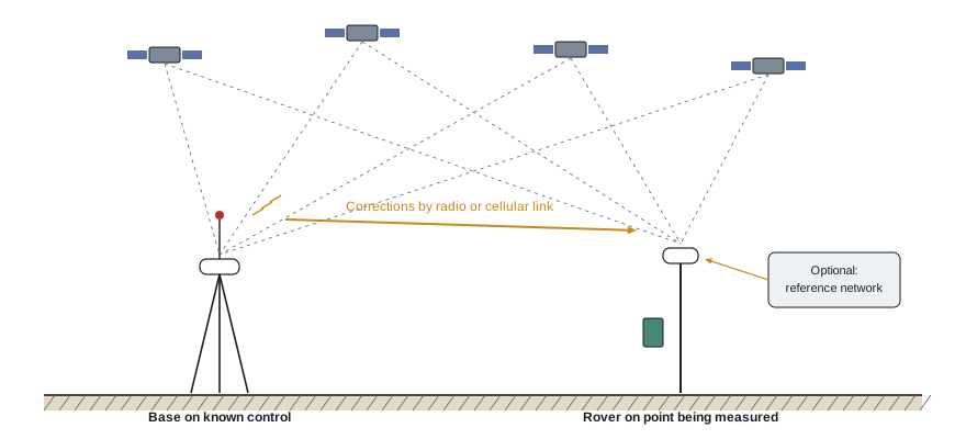
Network RTK replaces the site base with a network of permanent reference stations. Many state departments of transportation operate real-time networks, and commercial networks cover most populated areas. The National Geodetic Survey maintains the Continuously Operating Reference Station (CORS) network and offers a free online post-processing service, OPUS. Network corrections are convenient, but the coordinates they produce are in the network's datum and epoch, which may not match the project control exactly.
What limits GNSS accuracy
Several factors determine how good a GNSS position really is. The receiver displays estimated precision values, but these are statistical estimates, not guarantees, and they do not detect blunders such as a wrong antenna height.
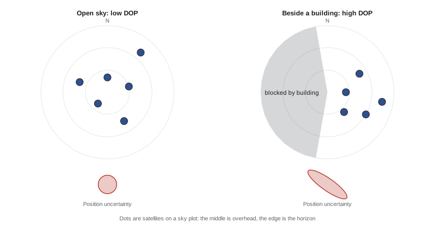
- Sky view and obstructions. Signals cannot pass through buildings, dense trees or the boom of a crane. Near tall structures, the rover may see too few satellites or only satellites on one side of the sky.
- Multipath. Signals that bounce off buildings, steel, vehicles or water arrive late and corrupt the range. Multipath is the most common cause of bad positions near structures, and it can produce a fixed solution that is centimeters wrong.
- Satellite geometry. Positions are strongest when satellites are spread across the sky. Dilution of precision (DOP) numbers express the geometry: low values (below about 2) are good, high values (above 4 to 6) mean the position is weak. Vertical precision is usually about 1.5 to 2 times worse than horizontal, because all satellites are above the horizon.
- Atmosphere. The ionosphere and troposphere delay signals. RTK removes most of this over short baselines; ionospheric storms during periods of high solar activity can prevent initialization or cause errors.
- Distance from the base and correction latency. Longer baselines and delayed corrections reduce accuracy.
- Antenna height and setup. A wrong pole height, a bent pole or a bubble out of adjustment produces errors that the receiver cannot detect.
Worked problem
Effect of satellite geometry
A rover's effective ranging precision is 0.025 ft. In open sky the horizontal DOP is 0.9; beside a building it rises to 3.5. Estimate the horizontal precision in each case.
Show solution
- Open sky: 0.9 × 0.025 = about 0.02 ft.
- Beside the building: 3.5 × 0.025 = about 0.09 ft.
- The same receiver is four times less precise near the building, before considering multipath, which can make it worse still.
Answer: About 0.02 ft in open sky against 0.09 ft beside the building.
Site calibration, or localization
GNSS receivers compute positions on a global datum. Project drawings are in a map projection or a local project grid with elevations on a particular vertical datum. Site calibration, also called localization, is the process that links the two. The surveyor occupies several control points with known project coordinates, at least three and preferably four or more spread around and outside the work area, and the software computes the best-fit transformation: a shift, a rotation, a scale and a vertical adjustment, often with a geoid model.
The software reports a residual at each calibration point, showing how well that point fits the transformation. Small, similar residuals mean the control and the transformation agree. A large residual on one point suggests that point was disturbed, misidentified or has a bad coordinate. A good calibration typically has horizontal residuals of 10 to 15 millimeters or less and vertical residuals of 20 millimeters or less, but the project specification governs.
Calibration rules every site should follow:
- Use control points that surround the work area. Positions outside the calibrated area are extrapolated, and errors grow quickly.
- Use the same calibration file on every rover and every machine on the project. Two machines with different calibrations will build two different sites.
- Check in on a known point at the start of every session and whenever the rover has lost lock for a while. Record the check.
- Do not recalibrate casually. A new calibration changes every coordinate; it should be done by the surveyor, documented and distributed.
Worked problem
Daily check on a benchmark
A rover checks into TBM A, whose project coordinates are N 4100.00, E 6905.00, elevation 329.02 ft. The rover reads N 4100.03, E 6904.98, elevation 329.11 ft. The site tolerance for checks is 0.06 ft horizontally and 0.06 ft vertically. Can the crew proceed?
Show solution
- Horizontal difference: √(0.03² + 0.02²) = 0.036 ft. This passes.
- Vertical difference: 329.11 − 329.02 = 0.09 ft. This fails.
- Check the pole height and antenna type in the data collector, the geoid model and the calibration file, then re-measure. Do not stake grades until the check passes.
Answer: No: horizontal is fine, but the 0.09 ft vertical error must be resolved first.
Choosing between GNSS and a total station
GNSS and total stations complement each other. GNSS works without line of sight between points, covers large open sites quickly and gives each point an independent position, so errors do not accumulate. A total station is more precise, especially vertically, works inside buildings and next to tall structures, and is the right tool for anchor bolts, column layout and anything needing a few millimeters. Most sites use GNSS for earthwork, utilities, paving and rough layout, and robotic total stations for structures.
| Situation | Better choice | Reason |
|---|---|---|
| Mass grading over a 20-hectare site | GNSS | Large area, open sky, centimeter tolerance |
| Anchor bolts for steel columns | Total station | Millimeter tolerance and better vertical accuracy |
| Interior wall layout on level 6 | Total station | No satellite signals indoors |
| Storm sewer along an open road | GNSS or total station | GNSS for alignment; check inverts with a level or total station |
| Topography under heavy tree cover | Total station | Canopy blocks and reflects signals |
| Stockpile volumes | Drone or GNSS | Large irregular surfaces; drone captures them fastest |
Laser scanning
A terrestrial laser scanner sits on a tripod and sweeps a laser beam across its surroundings, measuring the distance and direction to hundreds of thousands of points per second. The result is a point cloud: millions of points, each with coordinates and often color from built-in cameras. Several scans from different positions are registered together, using targets or overlapping geometry, and tied to project control. Mobile scanners carried by a person, mounted on a vehicle or carried on a backpack trade some accuracy for speed.
Construction uses scanning for:
- Existing conditions surveys of buildings to be renovated, so the design matches what is really there.
- Scan-to-BIM comparisons, overlaying the point cloud on the design model to find walls, embeds or mechanical systems that are out of position before the next trade builds on them.
- Floor flatness and levelness analysis and as-built verification of slabs.
- Monitoring deformation, such as excavation walls, adjacent buildings or temporary works.
Point clouds are large, often tens or hundreds of gigabytes, and they need processing, registration and quality control. Ask the provider for the registration report, which shows how well the scans fit together and to control.
Drones and photogrammetry
Drones, or remotely piloted aircraft systems, capture site data in two main ways. Photogrammetry takes hundreds of overlapping photographs and uses software to reconstruct a three-dimensional surface and an orthomosaic, a distortion-free aerial image. Lidar drones carry a laser scanner, which can measure the ground through gaps in vegetation. Typical construction uses are progress photographs, topographic surveys of open ground, stockpile volumes, earthwork progress and inspection of roofs and facades.
Accuracy depends on the ground sample distance (GSD), the size of one image pixel on the ground, and on ground control. GSD is set by the camera and the flying height.
Worked problem
Ground sample distance
A drone camera has a sensor width of 13.2 mm, a focal length of 8.8 mm and an image width of 5,472 pixels. What is the GSD when flying at 260 ft?
Show solution
- GSD = (13.2 × 260) ÷ (8.8 × 5,472) ft (the millimeters cancel).
- = 3,432 ÷ 48,154 = 0.0713 ft.
- About 0.07 ft, or 0.86 inch, per pixel. Vertical accuracy of the surface is typically 1 to 3 times the GSD when good control is used.
Answer: About 0.07 ft (0.86 inch) per pixel.
Ground control points (GCPs), marked targets surveyed with GNSS or a total station, tie the model to project coordinates. Independent check points, surveyed but not used in processing, show the real accuracy. Drones with RTK or post-processed kinematic positioning reduce, but do not eliminate, the need for ground control. Vegetation, standing water and dark or reflective surfaces reduce accuracy, and photogrammetry measures the top of whatever is there, such as grass or snow, not the ground underneath.
Drone flights are regulated. In the United States, commercial drone flights fall under FAA Part 107, which requires a Remote Pilot Certificate, registration of drones over 0.55 lb, Remote ID broadcast, visual line of sight, and limits on flying over people and in controlled airspace unless authorized. Site plans should also address flights over workers, cranes and neighbors.
Managing survey data
Modern survey tools produce large amounts of data, and much of the value lies in managing it well. Every rover, total station and machine should use the same control file, calibration and design surfaces, with version control so that a revised design reaches every device. Raw observations should be kept, not only the final coordinates, so that problems can be traced. As-built points, scans and drone surfaces should be stored with dates and the control they were tied to, because they become the evidence for progress payments, quantity disputes and future renovations.
Common mistakes
MistakeStaking with a float solution.
InsteadOnly stake with a fixed solution and acceptable precision values; wait or move if the rover cannot fix.
MistakeTrusting the precision estimate shown on the rover.
InsteadPrecision estimates do not catch multipath or setup blunders; check into known control every session.
MistakeCalibrating on control points clustered on one side of the site.
InsteadSurround the work area with calibration points; extrapolating outside them magnifies errors.
MistakeUsing different calibration files on different rovers or machines.
InsteadDistribute one controlled calibration file to every device and record which version is in use.
MistakeUsing GNSS for millimeter work beside tall buildings.
InsteadUse a total station for anchor bolts, column layout and work near structures.
MistakeAccepting a drone surface without independent check points.
InsteadSurvey check points that were not used in processing and compare them with the model.
Summary and key terms
- Survey GNSS measures the carrier phase and must resolve integer ambiguities to achieve a fixed solution.
- RTK uses a base on known control to send corrections; network RTK uses permanent reference stations.
- Obstructions, multipath, satellite geometry, atmosphere and setup errors limit GNSS accuracy; vertical is worse than horizontal.
- Site calibration fits GNSS positions to project coordinates; residuals show how well control agrees.
- Check into a known point every session, and use one calibration file for every device.
- Laser scanners produce point clouds for existing conditions, scan-to-BIM checks and monitoring.
- Drone accuracy depends on ground sample distance and ground control; check points prove the result.
- GNSS
- Global navigation satellite systems, including GPS, GLONASS, Galileo and BeiDou.
- Carrier phase
- Measurement of the radio wave cycles, which allows millimeter-level ranging.
- Fixed solution
- A GNSS position with integer ambiguities resolved, suitable for survey work.
- RTK
- Real-time kinematic positioning using corrections from a base or network.
- Multipath
- Signal reflections that corrupt GNSS ranges.
- DOP
- Dilution of precision: a measure of how satellite geometry affects accuracy.
- Site calibration
- The transformation that fits GNSS positions to project coordinates.
- Point cloud
- A dense set of measured three-dimensional points from a scanner or photogrammetry.
- Ground sample distance
- The ground size of one image pixel in aerial photography.
- Ground control point
- A surveyed target used to tie aerial data to project coordinates.
Practice problems
Work each problem on paper first, then reveal the answer to check.
What is the difference between a fixed and a float GNSS solution?
Show answer
A fixed solution has resolved the integer ambiguities and is accurate to centimeters; a float has not and may be wrong by decimeters.
Why is GNSS vertical precision worse than horizontal?
Show answer
All satellites are above the horizon, so the geometry in the vertical direction is weaker.
Name three causes of poor GNSS positions on a building site.
Show answer
Obstructions, multipath off structures, poor satellite geometry, long baselines, wrong pole height or antenna type.
A calibration shows residuals of 8, 10, 9 and 46 mm. What does this suggest?
Show answer
The point with 46 mm is probably disturbed, misidentified or has a wrong coordinate; investigate it and recalibrate without it if necessary.
Halving the flying height of a drone changes the GSD how?
Show answer
It halves the GSD, giving finer detail but needing more photographs and flight time.
A rover with 0.03 ft ranging precision has an HDOP of 2.5. Estimate the horizontal precision.
Show answer
About 0.075 ft.
Why should drone check points not be used in processing?
Show answer
So they give an independent measure of the model's accuracy.
Give two construction uses of laser scanning.
Show answer
Existing conditions, scan-to-BIM comparison, slab flatness checks, deformation monitoring.
Lesson quiz · 5 questions
Score 60% or more to complete this lesson.
Create a free account to save your progress, take quizzes and earn a certificate.