
CON-250 · Lesson 7 of 12 · 29 min
Grades, profiles and grade staking
Most of what a construction site does to the ground is about getting surfaces to the right height and slope. Parking lots must drain to catch basins. Sewers must flow by gravity at a steady slope. Roads need smooth vertical curves for sight distance and comfort. Building pads must be flat and at the right elevation. This lesson covers how grades are expressed and designed, how vertical curves work, how profiles and cross-sections describe the ground and the design, and how stakes communicate cuts, fills and slopes to the people running the equipment.
Expressing slope
Slope is expressed in several ways, and mixing them up is a frequent source of error on site.
- Percent grade: the rise or fall per 100 units of horizontal distance. A 2 percent grade rises 2 meters in 100 meters, or 0.02 per meter. Roads, parking lots, pipes and ramps are usually described in percent.
- Ratio, horizontal to vertical: side slopes of cuts, fills and ditches are written as H:V, such as 3:1 (three horizontal to one vertical). Some engineers write V:H, so always check which convention the drawings use. A 3:1 slope is 33.3 percent; a 2:1 slope is 50 percent.
- Angle: the slope angle in degrees, common for excavation safety rules and roofs. A 1:1 slope is 45°; 1.5:1 (horizontal to vertical) is about 34°.
- Inches per foot: used for drainage of floors, roofs and small pipes, such as 1/4 inch per foot (about 2.08 percent).
| Ratio (H:V) | Percent | Angle | Typical use |
|---|---|---|---|
| 1:1 | 100% | 45° | Steep cut in rock or with retaining |
| 1.5:1 | 66.7% | 33.7° | Common cut slope in firm soil |
| 2:1 | 50% | 26.6° | Embankment fill slopes |
| 3:1 | 33.3% | 18.4° | Mowable grass slopes, recoverable roadside slopes |
| 4:1 | 25% | 14.0° | Gentle slopes, ditches |
| 50:1 | 2% | 1.1° | Pavement cross slope, parking lot drainage |
Pipe grades and inverts
Gravity pipes, such as storm and sanitary sewers, are designed with a constant slope between manholes. The invert is the lowest inside point of the pipe, where the water runs, and invert elevations are given at each manhole or structure. The invert at any point along the pipe is found by interpolating along the slope.
Worked problem
Invert elevations along a sewer
A storm sewer leaves manhole 1 at an invert of 322.40 ft and runs 280.00 ft at 0.50 percent to manhole 2. What is the invert at manhole 2, and at a point 100.00 ft from manhole 1?
Show solution
- Fall over 280 ft = 280.00 × 0.005 = 1.40 ft.
- Invert at manhole 2 = 322.40 − 1.40 = 321.00 ft.
- Fall over 100 ft = 0.50 ft, so the invert there = 321.90 ft.
Answer: 321.00 ft at manhole 2 and 321.90 ft at 100 ft.
On site, pipe grade is commonly controlled with a pipe laser, which sits in the downstream manhole or the pipe itself and projects a beam up the center of the pipe at the set slope. A target in each new pipe length shows whether it is on line and grade. Grade is checked with a level or total station on the inverts at regular intervals and at every manhole. Flat sewers, at 0.3 to 0.5 percent, leave very little room for error: a 20 millimeter error over a 30 meter run of a 0.3 percent pipe changes the slope by about 0.07 percent, more than a fifth of the design slope.
Profiles
A profile is a vertical section along an alignment, drawn with stations on the horizontal axis and elevations on the vertical axis, usually with the vertical scale exaggerated ten times so that small slopes are visible. The profile shows the existing ground line, the proposed finished grade, and often pipes, structures and crossing utilities. The difference between proposed and existing at each station is the cut or fill.
The design grade line consists of straight grades, called tangents, joined by vertical curves. The points where two grades meet are points of vertical intersection (PVI). Profiles are the basis for staking grades, computing earthwork, and checking clearances where pipes cross.
Vertical curves
Where two grades meet, a vertical curve provides a smooth transition. Vertical curves on roads use a parabola rather than a circle, because the rate of change of grade is constant along a parabola and the calculations are simple. A crest curve occurs where the grade changes from rising to falling, or from steeper to less steep upward; a sag curve where it changes from falling to rising.
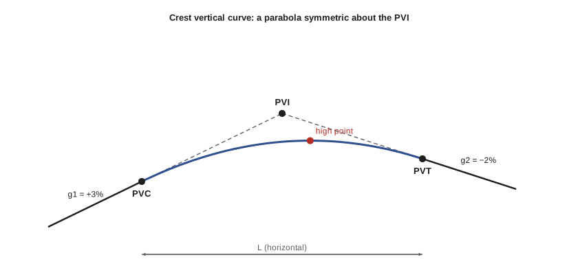
An equal-tangent vertical curve is centered on the PVI, so the point of vertical curvature (PVC) is L ÷ 2 before the PVI and the point of vertical tangency (PVT) is L ÷ 2 after it. The elevation at a distance x from the PVC is:
Grades g₁ and g₂ are written as decimals (0.03 for 3 percent), and x and L are in the same units as the elevations. The high or low point of the curve, where the grade is zero, is where water collects on a sag curve or sheds on a crest, and it is where catch basins or inlets go on a sag.
Worked problem
Elevations on a crest curve
A road grade of +3.0 percent meets a grade of −2.0 percent at PVI station 32+00.00, elevation 350.00 ft. The vertical curve is 400.00 ft long. Find the PVC and PVT, the elevation at station 31+00 and the high point.
Show solution
- PVC = 32+00 − 200 = 30+00.00, elevation 350.00 − 0.03 × 200 = 344.00 ft. PVT = 34+00.00, elevation 350.00 − 0.02 × 200 = 346.00 ft.
- At 31+00, x = 100: y = 344.00 + 0.03 × 100 + (−0.05 ÷ 800) × 100² = 344.00 + 3.00 − 0.625 = 346.375, or 346.38 ft.
- High point: x = −0.03 × 400 ÷ (−0.05) = 240 ft, at station 32+40.00.
- Elevation there = 344.00 + 0.03 × 240 − (0.05 ÷ 800) × 240² = 344.00 + 7.20 − 3.60 = 347.60 ft.
Answer: PVC 30+00 (344.00), PVT 34+00 (346.00); 346.38 ft at 31+00; high point at 32+40, elevation 347.60 ft.
The term (g₂ − g₁) ÷ L is the rate of change of grade. Designers often describe vertical curves by K, the horizontal distance needed for a 1 percent change in grade (K = L ÷ |A|, with A the algebraic difference in percent). Minimum K values for each design speed come from road design guides and are based on stopping sight distance on crests and headlight distance on sags.
Cross-sections
A cross-section is a vertical section perpendicular to the alignment at a given station. It shows the existing ground and the design template: for a road, the pavement, shoulders, ditches and side slopes. Cross-sections are typically taken at regular intervals and at every change in the ground or design. The area between the existing ground and the template, in cut or in fill, is the basis for the earthwork volumes in the next lesson.
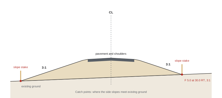
A design template defines the shape. For a two-lane site road it might be: a crowned pavement 7.0 meters wide with a 2 percent cross slope each side, gravel shoulders 1.0 meter wide at 4 percent, then a side slope of 3:1 in fill or 2:1 in cut down to or up to a ditch. The point where the side slope meets the existing ground is the catch point. Its location depends on the ground slope, so it must be found in the field or computed from the terrain model.
Grade stakes and how to read them
Stakes are the traditional way the surveyor tells the operator and the grade checker what to build. Each stake carries a hub or a mark at a known elevation, and the stake is written with the information needed: the station, the offset from the alignment, the design feature it refers to and the cut or fill.
- C 0.58 means cut 0.58 (meters or feet, depending on the project) from the hub or mark to reach the design grade.
- F 1.20 means fill 1.20 above the hub or mark.
- The reference feature is written too: FG for finished grade, SG for subgrade, TC for top of curb, EP for edge of pavement, INV for invert, CL for centerline.
- Offset stakes give the horizontal distance to the point, such as 3.0 m O/S RT to EP, meaning the edge of pavement is 3.0 meters from the stake toward the right of the alignment.
A stake at a known elevation lets the grade checker use a hand level, a laser or a string line to see how much more cut or fill is needed. Stakes are usually offset from the work so that they survive the equipment, and the offset distance and direction are written on them.
Worked problem
Reading and writing a grade stake
A hub is set at station 26+00, 12.00 ft left of the edge of pavement, at elevation 332.15 ft. The design subgrade at the edge of pavement is 330.25 ft. What is written on the stake?
Show solution
- Difference = 332.15 − 330.25 = 1.90 ft. The design is below the hub, so it is a cut.
- Stake: 26+00, 12.0 ft O/S LT EP, SG C 1.90.
- The grade checker measures 1.90 ft down from the hub elevation, carried across to the edge of pavement, to check the subgrade.
Answer: 26+00, 12.0 ft O/S LT EP, SG C 1.90.
Slope staking
Slope stakes mark the catch points, where the cut or fill slopes meet the ground, so the operator knows where to start the slope. The surveyor finds the catch point by trial: measure the ground elevation at a trial offset, compute what the offset would be if the ground were at that elevation, move, and repeat until the two agree within a few centimeters. Modern data collectors do the iteration automatically using the design template.
Here s is the side slope ratio (horizontal per unit vertical) and h is the height of cut or fill from the edge of the template to the ground at the catch point.
Worked problem
Catch point on level ground
A road template is 30.00 ft wide including shoulders (15.00 ft each side of the centerline). At a station, the shoulder edge is 5.00 ft above level existing ground, and the fill slope is 3:1. Where is the catch point?
Show solution
- Horizontal run of the slope = 3 × 5.00 = 15.00 ft.
- Catch offset = 15.00 + 15.00 = 30.00 ft from the centerline.
- The slope stake is set at the catch point or offset from it, marked for example 'F 5.0 at 30.0 ft RT, 3:1'. On sloping ground, the trial method would be needed because h changes with the offset.
Answer: About 30.0 ft from the centerline.
Grading building pads and parking lots
Building pads are graded flat to a subgrade elevation, typically the underside of the granular base below the slab, with a tolerance of perhaps ±20 to 30 millimeters. Grade is checked on a grid, often 5 to 10 meters, with a rotating laser or GNSS. Parking lots and paved areas are graded to drain to catch basins with minimum slopes, often 1 to 2 percent for asphalt and 0.5 to 1 percent for concrete, and maximum slopes for accessibility around entrances and accessible parking spaces.
Accessible routes under the ADA Standards are limited to running slopes of 1:20 (5 percent) unless designed as ramps, and cross slopes of 1:48 (about 2.08 percent); accessible parking spaces and access aisles are limited to 1:48 in all directions. Survey checks on accessible routes, curb ramps and parking spaces are an important part of the final grading inspection.
Finished grades around the building must slope away from the foundation, commonly at least 5 percent for the first 3 meters where the code requires it, so that water does not pond against the walls. These are small elevation differences that are easy to get wrong without survey control.
Common mistakes
MistakeConfusing H:V and V:H slope ratios.
InsteadCheck the drawing legend; a 2:1 slope may mean two horizontal to one vertical or the reverse.
MistakeMixing percent grade and slope ratio.
InsteadConvert to a common form: 3:1 (H:V) is 33.3 percent, not 3 percent.
MistakeReading a cut stake as a fill.
InsteadC means the design is below the reference mark; F means it is above. Confirm the reference feature (FG, SG, INV).
MistakePlacing the low point of a sag curve at the PVI.
InsteadCompute the low point from x = −g₁L ÷ (g₂ − g₁); it is at the PVI only for symmetrical grades.
MistakeChecking flat sewers only at the manholes.
InsteadCheck inverts along the run; on flat grades a small error is a large percentage of the slope.
MistakeAssuming the catch point is at a fixed offset.
InsteadOn sloping ground the catch point moves with the ground; find it by trial or from the terrain model.
Summary and key terms
- Slope can be expressed as percent, H:V ratio, angle or drop per length; always confirm the convention.
- Gravity pipes have constant slopes between structures; inverts are found by interpolation.
- Profiles show existing ground, design grades and vertical curves along an alignment.
- Vertical curves are parabolas: y = y(PVC) + g₁x + (g₂ − g₁)x² ÷ 2L.
- The high or low point is at x = −g₁L ÷ (g₂ − g₁).
- Cross-sections show the design template against the ground; catch points are where side slopes meet the ground.
- Grade stakes show station, offset, reference feature and cut or fill from a known mark.
- Percent grade
- Rise or fall per 100 units of horizontal distance.
- Invert
- The lowest inside elevation of a pipe or channel.
- Profile
- A vertical section along an alignment.
- PVI
- Point of vertical intersection of two grades.
- Vertical curve
- A parabolic curve connecting two grades.
- Crest and sag curve
- Vertical curves that are convex upward and concave upward.
- Cross-section
- A vertical section perpendicular to an alignment.
- Template
- The design shape of a road or channel cross-section.
- Catch point
- The point where a cut or fill slope meets existing ground.
- Grade stake
- A stake marked with the cut or fill to a design feature.
Practice problems
Work each problem on paper first, then reveal the answer to check.
Convert a 4:1 slope (H:V) to percent and to an angle.
Show answer
25 percent; about 14.0°.
A pipe falls 1.20 ft over 200 ft. What is its grade?
Show answer
0.60 percent.
A sewer invert is 310.00 ft at manhole A; it runs 240 ft at 1.0 percent. What is the invert at manhole B?
Show answer
307.60 ft.
Grades of −2 percent and +4 percent meet on a 150-unit sag curve. Where is the low point from the PVC?
Show answer
x = −(−0.02) × 150 ÷ (0.04 − (−0.02)) = 3 ÷ 0.06 = 50 units from the PVC.
A hub is at 173.20 ft and the design finished grade is 175.35 ft. What goes on the stake?
Show answer
FG F 2.15.
A fill slope of 2:1 starts 20.00 ft from the centerline, 6.00 ft above level ground. Where is the catch point?
Show answer
20.00 + 2 × 6.00 = 32.00 ft from the centerline.
What does 'SG' mean on a grade stake?
Show answer
Subgrade.
Why are sag curve low points important for drainage?
Show answer
Water collects there, so inlets or catch basins must be placed at the low point.
Lesson quiz · 5 questions
Score 60% or more to complete this lesson.
Create a free account to save your progress, take quizzes and earn a certificate.