
CON-110 · Lesson 1 of 12 · 26 min
Site investigation and soils for builders
Every building and every piece of infrastructure rests on the ground, and the ground is the one construction material that nobody designed. Soil and rock vary from site to site and even from one corner of a site to another, and the surprises they hide are among the most common causes of delays, cost overruns and failures in construction. This course follows the work from the ground up: site investigation and soils, site preparation, excavation, compaction, foundations, concrete, formwork, reinforcing, placement and curing, masonry, and the inspection and testing that confirm the work is right. This first lesson explains how builders learn what is under a site, how soils are described and classified, what a geotechnical report tells the construction team, and how ground conditions affect cost, schedule and safety. It does not train you to design foundations, which is the work of geotechnical and structural engineers, but it gives construction managers and supervisors the vocabulary and judgement to read reports, ask good questions and plan the work.
Why the ground matters to the constructor
Ground conditions affect almost every early decision on a project. They determine the type and depth of foundations, the method and cost of excavation, whether groundwater must be pumped or cut off, whether excavated soil can be reused as fill or must be hauled away, what temporary support excavations need, and what equipment will work on the site. Contaminated soil can trigger environmental requirements and disposal costs. Rock can require blasting or hydraulic breaking. Soft clays can make equipment sink and can settle under new loads for years. Many construction claims involve differing site conditions: ground that turned out to be different from what the contract documents indicated. A construction manager who understands soils can price risk realistically, plan methods and recognize early when conditions differ from what was expected.
How sites are investigated
Before design, the owner usually retains a geotechnical engineer to investigate the site. The investigation typically includes:
- A desk study: reviewing geological maps, previous reports, historical air photos, records of past land use and nearby construction, which may reveal old fill, buried structures, former industrial uses or springs.
- A site reconnaissance: walking the site to observe topography, drainage, vegetation, exposed soil and rock, and neighbouring buildings.
- Boreholes: drilling holes with truck- or track-mounted rigs, typically to depths below the expected foundation level, and recovering samples at intervals. Common methods include hollow-stem augers in soil and diamond coring in rock.
- Test pits: excavating trenches with a backhoe or excavator so the soil can be seen in place, useful for shallow foundations, fill and buried obstructions.
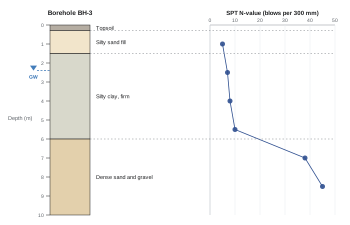
- In-situ tests: the standard penetration test (SPT), which counts the hammer blows needed to drive a sampler 300 mm (12 in), giving the N-value; cone penetration tests (CPT), which push an instrumented cone and record resistance continuously; and others such as vane shear tests in soft clay.
- Groundwater observations: noting water levels in boreholes and installing standpipes or piezometers to monitor levels over time.
- Laboratory tests: moisture content, grain size, plasticity, density, strength, consolidation and chemical tests such as sulphate content, which affects concrete durability.
Investigations cost money, and owners sometimes limit them. A small number of widely spaced boreholes can miss soft pockets, boulders or old foundations between them. Construction managers should understand that the ground between boreholes is interpreted, not known.
Describing and classifying soils
Soils are mixtures of mineral particles, water and air, sometimes with organic matter. They are first described by particle size:
| Soil type | Particle size | Key behaviour for construction |
|---|---|---|
| Boulders and cobbles | Larger than about 75 mm | Obstruct excavation, piling and drilling |
| Gravel | About 4.75 mm to 75 mm | Free-draining, strong, good fill |
| Sand | About 0.075 mm to 4.75 mm | Drains well, compacts well, can run when saturated |
| Silt | About 0.002 mm to 0.075 mm | Frost-susceptible, loses strength when wet, hard to compact |
| Clay | Finer than about 0.002 mm | Cohesive, plastic, low permeability, can shrink, swell and settle |
| Organic soils and peat | Varies | Compressible and weak; usually removed |
Coarse-grained soils, gravels and sands, get their strength mainly from friction between grains and are described as granular or cohesionless. Fine-grained soils, silts and clays, behave differently: clays are cohesive, holding together when moist, and their behaviour depends strongly on water content. The Unified Soil Classification System (USCS, ASTM D2487) is widely used in both countries and assigns two-letter symbols such as GW (well-graded gravel), SP (poorly graded sand), SM (silty sand), ML (silt), CL (lean clay) and CH (fat clay). Atterberg limits, the liquid limit and plastic limit, describe the water contents at which a fine soil changes from solid to plastic to liquid behaviour; their difference is the plasticity index. High-plasticity clays tend to shrink and swell with changes in moisture, which can damage slabs and light foundations.
Field descriptions also note density for granular soils (very loose to very dense, often from SPT N-values) and consistency for cohesive soils (very soft to hard), plus colour, moisture, structure and any odour or staining that may indicate contamination.
Rock
Rock is described by its type, such as limestone, shale, sandstone, granite or gneiss, and by its quality. Rock quality designation (RQD), the percentage of a core run made up of pieces at least 100 mm (4 in) long, gives an indication of fracturing. Weathered rock near the surface may behave more like dense soil. Rock is usually an excellent foundation, but excavating it is slow and expensive, and its surface can be irregular, so a design that assumes rock at a certain level may find it higher or lower in places. Some rocks, such as shales, deteriorate when exposed to air and water and must be protected quickly after excavation.
Groundwater
Groundwater affects excavation, foundations and long-term building performance. Excavating below the water table in sands and silts can cause water and soil to flow into the excavation, undermining slopes and neighbouring structures. Water pressure on basement walls and slabs must be resisted or relieved by drainage. Groundwater levels vary seasonally and may be higher in spring than at the time of the investigation, so reports often give a range. Artesian conditions, in which water in a confined layer is under pressure, can cause blow-ups in the bottom of excavations. Lesson 3 covers dewatering.
Frost
In much of Canada and the northern United States, frost is a major consideration. When water in fine-grained soils, particularly silts, freezes, ice lenses can form and grow, lifting the ground and anything on it, a process called frost heave. Foundations are therefore placed below the expected depth of frost penetration, or protected with insulation. Frost depths vary widely, from well under 1 m in mild coastal areas to over 2 m in parts of the Prairies and the North, and local building codes and authorities specify minimum depths. Frozen ground must also not be used as a base for footings or slabs, and soil placed as fill must not be frozen. In permafrost regions of the Canadian North and Alaska, foundations are designed to keep the ground frozen, often using piles, air gaps or thermosyphons.
The geotechnical report
The geotechnical engineer's findings are presented in a report that construction managers should read carefully. A typical report includes the scope and methods of the investigation, a site plan showing borehole and test pit locations, borehole logs, laboratory results, groundwater observations, and recommendations: foundation types and bearing capacities, settlement estimates, slab-on-grade support, excavation and temporary support, dewatering, backfill and compaction requirements, frost protection, seismic site class, concrete exposure requirements for sulphates, and construction inspection requirements. It also contains limitations, reminding readers that conditions between boreholes may vary.
For construction, the most useful parts are often the borehole logs, the groundwater observations, and the recommendations for excavation, dewatering, reuse of excavated soil and compaction. Estimators use the logs to price excavation and disposal; site supervisors use them to anticipate wet or soft conditions.
In Canada, geotechnical reports are prepared by professional engineers licensed by provincial associations such as Professional Engineers Ontario or Engineers and Geoscientists British Columbia. Building codes based on the National Building Code of Canada require foundation design to be based on subsurface investigation appropriate to the building, and many municipalities require geotechnical reports for permits on larger projects.
Worked problem
Reading a borehole log for excavation planning
A borehole log for a building with one basement level shows 0.3 m of topsoil, fill to 1.5 m, soft grey silty clay to 6 m with SPT N-values of 3 to 6, and groundwater at 2.4 m. The basement excavation will be 4 m deep. What should the construction team anticipate?
Show solution
- Topsoil must be stripped and stockpiled or removed; it is not suitable as structural fill.
- The fill may contain debris or old foundations and may not be reusable; plan for testing and possible disposal.
- Soft clay with low N-values will be weak, so slopes must be flatter or shoring used; equipment may need mats.
- The 4 m excavation extends about 1.6 m below the groundwater level, so dewatering or groundwater control will likely be needed, though seepage into clay may be slow.
- The base of the excavation will be in soft clay, which may be disturbed by equipment; the geotechnical engineer may require a working mat of granular material or concrete.
Answer: Expect topsoil stripping, uncertain fill, soft clay needing support and careful handling, and groundwater control below 2.4 m; confirm methods with the geotechnical engineer.
Contaminated and problematic ground
Former industrial sites, gas stations, rail yards and landfills may contain contaminated soil or groundwater. Environmental site assessments, usually in phases, identify potential contamination before purchase or development. During construction, contaminated soil must be handled, stored, transported and disposed of according to environmental regulations, which can add substantial cost. Other problematic ground includes expansive clays, collapsible soils that lose volume when wetted, sensitive marine clays found along parts of the St. Lawrence and Ottawa valleys that can lose strength dramatically when disturbed, karst limestone with voids, and old mine workings. Each needs specialist advice.
Differing site conditions
Because ground conditions can never be fully known in advance, construction contracts allocate the risk of unexpected conditions. Many standard contracts include a differing site conditions or concealed conditions clause, under which a contractor who encounters conditions materially different from those indicated in the contract documents, or from those ordinarily encountered, may be entitled to an adjustment in price and time if it gives prompt notice. Contractors protect themselves by reviewing geotechnical information carefully during bidding, documenting conditions encountered with photos and records, notifying the owner and consultant immediately, and not disturbing the conditions until they can be inspected. CON-220 covers construction contracts in detail.
Using the report on site
A geotechnical report is not only a design document; it is a working tool for the site team. Superintendents and project managers should read the recommendations section in full before mobilizing, because it often contains requirements that affect the schedule and cost directly: the depth at which bearing soil is expected, whether subgrade must be protected from rain and frost, how long excavations may stay open, the type of fill that is acceptable, the frequency of compaction testing, and whether the geotechnical engineer must review each footing before concrete is placed. Many reports also give advice about temporary works, such as safe excavation slopes, expected groundwater inflow and suitable dewatering methods, and some contain warnings about sensitive clays that lose strength when disturbed or about organic soils that must be removed completely.
It is useful to mark up the borehole locations on the site plan and keep it in the site office, so that when excavation exposes something unexpected the team can compare it with the nearest borehole. Boreholes describe the ground only at the points where they were drilled, and conditions between them are interpreted. A layer of soft clay that appears in one borehole and not in the next may thin out, or it may continue as a pocket under part of the building. The site team should photograph and record the soils exposed in every excavation, note the depth of groundwater seepage and the weather, and share these records with the geotechnical engineer. Good records of actual conditions are the basis of any claim for differing site conditions and help the engineer decide quickly whether a change in design is needed.
Common mistakes
MistakeAssuming the ground between boreholes matches the logs exactly.
InsteadTreat interpolated conditions as uncertain and plan contingencies.
MistakeIgnoring groundwater observations when planning excavation.
InsteadUse reported levels and seasonal ranges to plan dewatering.
MistakePlacing footings or fill on frozen ground.
InsteadProtect subgrades from frost and never build on frozen soil.
MistakeReusing excavated soil without checking its suitability.
InsteadFollow the geotechnical report and test before reuse.
MistakeContinuing work after finding unexpected ground conditions.
InsteadStop, document and notify promptly under the contract.
Summary and key terms
- Ground conditions shape foundations, excavation, dewatering, cost and schedule.
- Investigations use desk studies, boreholes, test pits, in-situ tests and lab tests.
- Soils are described by particle size, density or consistency, plasticity and moisture.
- Groundwater and frost are critical for excavation and foundation depth.
- Geotechnical reports give logs, results, recommendations and limitations.
- Contaminated and problematic soils need specialist advice.
- Differing site conditions clauses allocate the risk of surprises.
- Geotechnical engineer
- Engineer specializing in soil and rock behaviour.
- Borehole
- Drilled hole used to sample and test the ground.
- Test pit
- Excavated trench for viewing soil in place.
- SPT N-value
- Blows to drive a standard sampler 300 mm (12 in).
- USCS
- Unified Soil Classification System.
- Plasticity index
- Difference between liquid and plastic limits.
- RQD
- Rock quality designation, a measure of fracturing.
- Frost heave
- Ground uplift caused by growing ice lenses.
- Water table
- Level below which the ground is saturated.
- Differing site conditions
- Ground materially different from what the contract indicated.
Practice problems
Work each problem on paper first, then reveal the answer to check.
Name three things ground conditions affect.
Show answer
Foundations, excavation methods, dewatering, fill reuse, cost and schedule.
What does an SPT measure?
Show answer
Blows needed to drive a sampler 300 mm.
Why are test pits useful?
Show answer
They show soil, fill and obstructions in place.
Which soil is most frost-susceptible?
Show answer
Silt.
What does a high plasticity index suggest?
Show answer
A clay that may shrink and swell.
What does RQD describe?
Show answer
How fractured rock is.
Why may groundwater levels differ at construction time?
Show answer
They vary seasonally.
Name two parts of a geotechnical report useful to estimators.
Show answer
Borehole logs, groundwater observations, reuse and compaction recommendations.
Name a problematic soil.
Show answer
Expansive clay, sensitive marine clay, collapsible soil, peat.
What should a contractor do on finding unexpected ground?
Show answer
Stop, document and notify promptly.
Lesson quiz · 5 questions
Score 60% or more to complete this lesson.
Create a free account to save your progress, take quizzes and earn a certificate.